The Confluence of Geography and Civilizational Memory
Ram Setu represents one of the most profound intersections of geological reality and civilizational memory in the Indian subcontinent. Stretching approximately 48 kilometres across the Palk Strait, this chain of limestone shoals connects the southeastern tip of Pamban Island in Tamil Nadu, India, to the northwestern coast of Mannar Island in Sri Lanka.1 To the uninitiated eye, it appears as a submerged ridge of coral and sand, a barrier separating the turbulent Bay of Bengal from the tranquil Gulf of Mannar. However, within the Sanatani worldview, it is a living monument—a physical testament to the Itihasa (history) of the Ramayana and the engineering prowess of the Vanara Sena under the guidance of Lord Rama.3
The structure’s physical characteristics are as compelling as its mythology. The ridge is composed of discontinuous limestone shoals, coral reefs, and shallow sandbanks, with depths ranging from a mere 1 meter to 10 meters, rendering it impassable to large maritime vessels.2 This distinct bathymetry has served as both a bridge for terrestrial migration during glacial epochs and a barrier to navigation in historical times.
Recent years have seen Ram Setu move from the pages of scripture to the centre of scientific inquiry and legal debate. From underwater archaeological expeditions approved by the Government of India to high-resolution satellite mapping by ISRO and NASA, the quest to understand the origins—whether natural or anthropogenic—of this causeway has intensified.5 Concurrently, the legal battle to declare it a National Heritage Monument has reached the Supreme Court of India, highlighting the tension between developmental economics and the preservation of sacred heritage.7 This report seeks to provide an exhaustive analysis of Ram Setu, exploring its geological formation, its profound scriptural significance, its ecological role, and its enduring presence in the cultural consciousness of Bharat.
Geological Framework and Oceanographic Context
To understand Ram Setu, one must first interrogate the geological forces that shaped the Palk Strait and the Gulf of Mannar. The region acts as a dynamic interface between two major water bodies, governed by complex tectonic history and eustatic sea-level fluctuations.
Physical Composition and Bathymetry
Ram Setu acts as a grade divide. To its north lies the Palk Bay, characterised by high turbidity and rougher waters, while to its south lies the Gulf of Mannar, known for its pristine, clear waters and rich biodiversity.8 The ridge itself is a linear chain of shoals. The width of this formation varies significantly, from narrow sandbanks to wider coral formations, creating a “dotted line” appearance from aerial perspectives.1
The water depth across the ridge is exceptionally shallow, typically between 1 to 3 meters (3 to 10 feet), with certain sections exposed as dry land during low tides.1 This shallowness contrasts sharply with the surrounding seabed, which drops to deeper levels on either side, effectively creating a submarine wall. Oceanographic studies indicate that this barrier prevents the free exchange of sediment and water masses between the Bay of Bengal and the Gulf of Mannar, creating distinct ecological niches on either side.9
Tectonic History and Plate Dynamics
Geological evidence suggests that India and Sri Lanka were part of the same landmass within the Gondwana supercontinent. They drifted northward, eventually colliding with the Laurasian plate. The separation of Sri Lanka from the Indian mainland is a relatively recent geological event, estimated to have occurred approximately 125,000 years ago during interglacial periods.10
The region around Ram Setu is tectonically active, though often described as stable. Researchers from the Geological Survey of India (GSI) and other institutions have noted evidence of vertical tectonic movements. Specifically, marine terraces and the submergence of land near Dhanushkodi indicate crustal adjustments that have influenced the elevation of the ridge over millennia.11 The presence of calcareous rectangular blocks and specific fault lines suggests that the separation of the two landmasses was driven by these tectonic shifts, leaving the ridge as a remnant connection.10
Eustatic Sea-Level Fluctuations: The Glacial Bridge
The most critical factor in the history of Ram Setu is the fluctuation of global sea levels during the Pleistocene and Holocene epochs.
- Last Glacial Maximum (LGM): During the Last Glacial Period (approx. 115,000 to 11,700 years Before Present), massive volumes of water were locked in polar ice caps. Global sea levels dropped by as much as 120 meters (390 feet) below present levels.1
- The Land Bridge: During these periods of regression, the shallow continental shelf of the Palk Strait—which reaches a maximum depth of only 35 meters—was entirely exposed. Ram Setu would have been a prominent high-ground ridge within a continuous land connection between India and Sri Lanka.1 This allowed for the migration of flora, fauna, and early human populations.
- Holocene Transgression: Following the end of the ice age, deglaciation led to a rapid rise in sea levels (The Flandrian Transgression). By approximately 7,000 to 7,500 years ago, sea levels stabilised near modern norms, submerging the lower-lying areas and leaving the Ram Setu ridge as a chain of islands and shoals.2
Sedimentation and Longshore Drift
Currents play a vital role in maintaining the structure. The Palk Strait is dominated by longshore currents that flow in opposite directions from the Gulf of Mannar and the Palk Bay. These currents converge at the ridge, leading to the settlement of sediments.9 Over thousands of years, this continuous deposition of sand, combined with the growth of coral colonies on the hard substrate, has built up the shoals. Some geologists argue that this “tombolo” effect—where an island (Sri Lanka) is connected to the mainland by a sediment bar—is the primary mechanism of its natural formation.9
The Sanatani Perspective: Scriptural Epistemology and History
In the Sanatani tradition, geography is rarely secular; it is imbued with the divine. Ram Setu is not merely a geological feature but a Tirtha—a crossing point between the material and the spiritual. Its construction is detailed in the Itihasa (Ramayana), and its spiritual efficacy is extolled in the Puranas.
The Valmiki Ramayana: Engineering the Impossible
The primary historical account of the Setu is found in the Yuddha Kanda (Book of War) of the Valmiki Ramayana. The epic provides a detailed narrative of the logistics, engineering, and divine intervention involved in its construction.
- The Prayer to Samudra: Upon reaching the shores of the southern ocean, Lord Rama sought passage to Lanka to rescue Sita. For three days, he prayed to Samudra, the Ocean God. When the ocean did not yield, Rama, displaying his prowess, threatened to dry up the waters with his celestial weapons (Brahmastra). Samudra appeared, pleading that nature’s laws could not be broken, but suggested a solution: Nala, a Vanara in Rama’s army.14
- Nala and Nila: Nala was the son of Vishwakarma, the divine architect. He possessed the genetic knowledge and boon to construct structures on water. Alongside his brother Nila, he supervised the Vanara Sena.4
- Construction Methodology: The text describes the army uprooting massive trees (Sal, Asoka, Bamboo) and transporting huge boulders and mountains to the shore. The sheer scale of the operation is quantified:
- Day 1: 14 Yojanas completed.
- Day 2: 20 Yojanas.
- Day 3: 21 Yojanas.
- Day 4: 22 Yojanas.
- Day 5: 23 Yojanas.
- Total: 100 Yojanas in length and 10 Yojanas in width.13
- The Floating Phenomenon: The Ramayana explicitly mentions that the rocks and trees thrown into the ocean defied gravity and floated, binding together to form a causeway capable of supporting the millions of Vanara warriors. This “floating” capability is attributed to the engineering skill of Nala and the divine grace of Rama’s name inscribed upon them.3
The Skanda Purana: The Setu Mahatmya
While the Ramayana details the history of the bridge, the Skanda Purana details its soteriology—its power to save souls. The Setu Mahatmya (Glory of the Bridge) section of the Brahma Khanda offers an exhaustive spiritual guide to the site.
- Absolution of Sins: The text asserts that the Setu is the ultimate destroyer of sins (Papahara). It claims that specific acts at the Setu grant specific reliefs:
- Wind: The touch of the wind blowing from the Setu destroys the sin of consuming intoxicants (Surapana).16
- Sand: Rolling in the sands of the Setu absolves one of Brahmahatya (the sin of killing a Brahmin). The text metaphorically states that for every grain of sand that sticks to the body, a sin is washed away.16
- Darshan: Mere sight of the bridge ensures liberation from the cycle of birth and death (Samsara).18
- Establishment of the Linga: The Skanda Purana narrates that Lord Rama established a Shiva Linga (Rameswaram) at the bridgehead to worship Lord Shiva before and after the war. This establishes the profound unity between Shaivism and Vaishnavism, where Rama (Vishnu) worships Shiva, and Shiva reveres Rama.16
- The Tirthas: The text catalogues various holy water bodies (Theerthams) around the Setu, such as Dhanushkodi, Chakra Tirtha, and Vetalavarada, prescribing elaborate rituals for the pitrus (ancestors) at these sites.19
Other Scriptural Corroborations
- Vishnu Purana & Agni Purana: These texts reinforce the sanctity of the site, declaring that any person who bathes near the Setu attains Mukti (liberation) and that offerings made here to ancestors are imperishable.14
- Kurma Purana: As one of the eighteen Mahapuranas narrated by Lord Vishnu in his Kurma (Tortoise) avatar, this text links the cosmological support of the earth to the geography of Bharat, implicitly validating the sacred geography of the south.20
- Garuda Purana: This text, dealing with the afterlife and funeral rites, underscores the importance of southern pilgrimages for the salvation of the departed, cementing Ram Setu’s role in Hindu eschatology.22
The Controversy of Origins: Natural Formation or Ancient Engineering?
The question of whether Ram Setu is a natural geological formation or a man-made structure remains one of the most contentious debates in modern Indian science and politics.
The “Man-Made” Hypothesis
Proponents of the anthropogenic origin theory rely on geological anomalies that are difficult to explain through standard sedimentation models.
- Inversion of Stratigraphy: Dr. S. Badrinarayanan, former director of the Geological Survey of India (GSI), has highlighted a critical anomaly. Geological surveys involving boreholes revealed that while the top layer consists of hard coral and calcareous sandstone, the layer immediately beneath it consists of loose marine sand, followed by hard rock again at deeper levels.8
- Implication: Corals typically require a hard substrate (rock) to grow. They cannot form naturally on loose sand. The presence of loose sand beneath the hard coral layer suggests that the hard material (boulders/rocks) was transported and placed on top of the sand, providing an artificial foundation for subsequent coral growth.8
- Linearity: The structure exhibits a high degree of linearity (straightness) over a long distance (48km). Natural shoal formations are typically irregular, curved, or chaotic. The geometric precision of the ridge is cited as evidence of intelligent design or engineering.2
- The “Floating Stones” (Pumice): In Rameswaram, stones that float on water are found and worshipped. Scientifically, these are often identified as pumice (volcanic rock with high porosity). However, critics note there is no proximate source of volcanic activity in the region. This has led to theories that these stones were either brought from afar (as described in the Ramayana) or are a unique type of lightweight coral limestone modified by ancient engineers.3
- Chronological Alignment: Carbon dating of some organic materials in the region yields dates between 7,000 and 18,000 years BP. This overlaps with the traditional timeline of the Ramayana (Treta Yuga), leading some to argue that the “bridge” was a modification of a natural ridge during a time of lower sea levels to make it passable.9
The “Natural Formation” Hypothesis
Mainstream oceanography and government bodies (during the UPA administration) have argued for a purely natural origin.
- Tombolo Formation: The ridge is viewed as a result of continuous sand deposition where the currents of the Gulf of Mannar and Palk Bay meet. Over millennia, this sedimentation created a land connection.9
- Sea Level Regression: Geologists argue that during the Last Glacial Maximum, the entire shelf was dry land. The ridge is simply a geological high point that remained partially exposed after sea levels rose. The “man-made” appearance is attributed to the natural tendency of coral reefs to grow on ridgelines.1
- Satellite Imagery Interpretation: NASA has officially stated that while satellite images show a “chain of shoals,” the images themselves do not prove human construction. They clarify that the “bridge” is a natural geological feature.5
Scientific Investigations (2021-2025)
To resolve this, the Government of India initiated a major underwater exploration project led by the National Institute of Oceanography (NIO) and the Archaeological Survey of India (ASI).
- Methodology: Using the research vessel RV Sindhu Sadhana, scientists collected sediment cores from 35-40 meters depth and utilised Side-Scan Sonar and Silo Seismic Surveys to map the sub-surface structure.25
- Findings (2024-2025): Recent collaborations between ISRO and NASA using the ICESat-2 satellite have produced the first high-resolution undersea map of the entire bridge. The map confirms the structural continuity of the ridge from Dhanushkodi to Talaimannar, revealing it to be 99.98% submerged with 11 narrow channels allowing water flow. While stopping short of declaring it “man-made,” the detailed topography confirms it was a continuous land link in the recent geological past.5
Ecological Sanctuary: The Gulf of Mannar Biosphere Reserve
Beyond its mythological and geological status, Ram Setu is a cornerstone of one of the world’s most vital marine ecosystems.
Biodiversity Hotspot
The Setu separates the Palk Bay from the Gulf of Mannar. The latter was declared a Marine Biosphere Reserve in 1989, the first of its kind in South and Southeast Asia.28
- Flora and Fauna: The reserve covers 10,500 sq. km and harbours over 3,600 species of plants and animals. This includes 117 species of corals, 14 species of seagrasses (such as Halophila and Cymodocea), and extensive mangrove forests.28
- Endangered Species: It is a critical habitat for the Dugong (Dugong dugon), a vulnerable marine mammal that grazes on the seagrass beds protected by the calm waters behind the Setu. It also supports five species of marine turtles, including the Olive Ridley and Green Turtle.30
The Protective Shield (Tsunami Mitigation)
The ecological value of Ram Setu was dramatically demonstrated during the 2004 Indian Ocean Tsunami.
- Wave Attenuation: Scientific models and observational data indicated that the Ram Setu ridge acted as a natural breakwater. It absorbed and diffracted the energy of the tsunami waves travelling from the southeast.
- Impact: Consequently, the coastline of the Palk Bay (north of the bridge) suffered significantly less damage compared to the exposed coastlines of Nagapattinam and Chennai. The ridge effectively shielded the southern coast of Kerala and parts of Tamil Nadu from the direct fury of the waves.18
The Sethusamudram Shipping Canal Project (SSCP)
The Sethusamudram Shipping Canal Project (SSCP) represents the modern conflict between industrial development and heritage conservation.
Project Rationale and History
First conceived in 1860 by Commander A.D. Taylor, the project aimed to dredge a navigable canal across the Palk Strait. The objective was to allow ships travelling between India’s east and west coasts to bypass the circumnavigation of Sri Lanka, potentially saving 30 hours of travel time and up to 424 nautical miles.32
The Battle of Alignments: 6 vs. 4A
The controversy centred on the route of the dredging.
- Alignment 6: This was the original proposed route. It cut directly through the Ram Setu ridge. While technically the most direct path, it required dredging the limestone shoals, effectively destroying the physical integrity of the “Rama’s Bridge.” This alignment faced fierce opposition from religious groups and heritage activists.33
- Alignment 4A: Following a Supreme Court directive in 2008, the Pachauri Committee was appointed to investigate an alternative. Alignment 4A proposed cutting through the spit of land near Dhanushkodi, avoiding the main limestone ridge of Ram Setu.
- Findings on 4A: The National Institute of Oceanography (NIO) studied Alignment 4A and found it ecologically and geologically risky. They reported that cutting through the Dhanushkodi spit would destabilise the coastline and that the high rate of sediment transport in the region would necessitate perpetual, costly maintenance dredging. Furthermore, it was deemed that Alignment 4A could be more vulnerable to cyclone damage than Alignment 6.33
Economic and Ecological Viability
Critics of the SSCP argued that the project was flawed regardless of the alignment.
- Depth Limitations: The canal was designed for a depth of 12 meters. Modern Panamax and Suezmax vessels, which form the backbone of international shipping, require depths of 14 meters or more. Therefore, the canal would only serve smaller coastal vessels, limiting its economic utility.32
- Ecological Disaster: Dredging millions of cubic meters of sediment would increase water turbidity, smothering the coral reefs and seagrass beds of the Biosphere Reserve. This would collapse the local fishery economy and destroy the habitat of the Dugong.31
Legal Battles and the Quest for National Monument Status
The struggle to protect Ram Setu has been fought as intensely in the courtrooms of New Delhi as in the public sphere.
The 2007 Affidavit Crisis
In 2007, during the hearing of petitions against the SSCP, the Archaeological Survey of India (ASI) filed an affidavit in the Supreme Court stating that there was no historical evidence to prove the existence of Lord Rama or the events of the Ramayana. This dismissal of the text as “mythology” sparked nationwide protests. The UPA government was forced to withdraw the affidavit, and the case was subsequently paused.35
The NDA Government’s Stance (2018)
In 2018, the NDA government filed a new affidavit, stating that it would not touch Ram Setu for the implementation of the SSCP. The Ministry of Shipping affirmed that it would explore alternatives that did not involve damaging the sacred structure, citing its “socio-economic disadvantages” and “strategic importance” (referencing thorium deposits).35
Supreme Court Proceedings (2025)
The focus has now shifted to declaring Ram Setu a National Heritage Monument.
- The Petitioner: Dr. Subramanian Swamy has been the primary litigant, arguing that Ram Setu meets the criteria of the Ancient Monuments and Archaeological Sites and Remains Act, 1958. He contends that the site is over 100 years old (Section 3) and is of immense historical and artistic interest.38
- Recent Notices (August 2025): On August 29, 2025, the Supreme Court issued a notice to the Union Government, demanding an expeditious decision on Dr. Swamy’s representation. The court expressed dissatisfaction with the delay, as the government had previously stated the matter was “under consideration” by the Ministry of Culture. The Solicitor General was directed to clarify the government’s timeline for notifying the monument.7
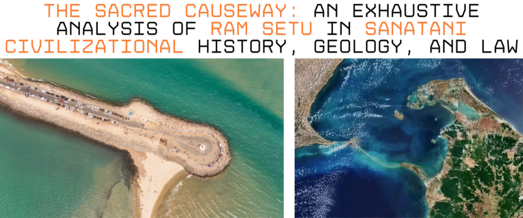
Dhanushkodi: The Ghost Town at the Ram Setu’s Edge
At the Indian terminus of Ram Setu lies Dhanushkodi, a place that serves as a grim reminder of nature’s power and a vibrant testament to faith.
The 1964 Cyclone
Until 1964, Dhanushkodi was a bustling port town with a railway station, customs office, and ferry service to Talaimannar (Sri Lanka). On the night of December 22, 1964, a super-cyclone with wind speeds of 280 km/h struck the town. Tidal waves estimated at 7 meters high engulfed the land. The Pamban-Dhanushkodi passenger train (No. 653) was washed away into the sea, killing all 115 passengers on board. The entire town was destroyed and subsequently declared “unfit for habitation” by the Madras Government.12
Current State: Ruins and Resilience
Today, Dhanushkodi is a haunting landscape of ruins. The skeleton of the church, the water tank of the railway station, and the remnants of the post office stand amidst the shifting sands. Despite its “ghost town” status, it remains a major pilgrimage site.
- The Confluence: Pilgrims travel to Arichal Munai (the erosion point) to witness the meeting of the Bay of Bengal (Mahodadhi) and the Indian Ocean (Ratnakara). The waters here are believed to be sacred, and taking a dip is considered equivalent to bathing in the Ganges.42
- Visual Travelogue: The journey to Dhanushkodi, once possible only by 4WD trucks through deep sand, is now accessible via a new road inaugurated in 2017. The drive offers surreal views: deep blue ocean on one side, calm turquoise bay on the other, and the endless stretch of sand leading to the submerged Setu.44
Conclusion
Ram Setu is a structure that defies singular categorisation. To the geologist, it is a fascinating archive of sea-level change and tectonic history. To the ecologist, it is a vital shield protecting one of the world’s most fragile marine reserves. To the historian, it is a remnant of ancient connectivity that bound the subcontinent together.
However, its most enduring identity is spiritual. For millions of Sanatanis, Ram Setu is not a subject of debate but an object of veneration. It is the path walked by the Maryada Purushottam, a bridge built not just of stone and coral, but of devotion (Bhakti) and righteousness (Dharma). The “floating stones” of Rameswaram and the ruins of Dhanushkodi serve as tangible anchors for this faith.
As the Supreme Court of India moves towards a decision in late 2025 regarding its status as a National Monument, the preservation of Ram Setu is no longer just about protecting a geological formation; it is about honouring the civilizational soul of Bharat. Whether formed by the currents of the Holocene or the hands of the Vanara Sena, Ram Setu remains an indestructible bridge between the past and the present, ensuring that the legacy of the Ramayana continues to flow through the waters of the Indian Ocean.
Table 1: Scientific vs. Mythological Attributes of Ram Setu
| Attribute | Scientific / Geological Perspective | Sanatani / Mythological Perspective |
| Origin | Natural sedimentation, coral growth, and tectonic uplift.9 | Constructed by Vanara Sena, led by Nala & Nila.14 |
| Time Period | 7,000–18,000 BP (Post-Glacial).9 | Treta Yuga (approx. 1.7 million years ago).46 |
| Composition | Limestone shoals, coral reefs, sandstone.2 | Stones and trees made to float by Divine Name.15 |
| Function | Barrier between Palk Bay & Gulf of Mannar.9 | Causeway for Rama’s army to reach Lanka.3 |
| Status | Geological feature; Biosphere Reserve boundary.28 | Sacred Tirtha; Destroyer of Sins (Papahara).16 |
Table 2: Key Legal and Political Milestones (2005-2025)
| Date | Event | Significance |
| 2005 | SSCP Inaugurated | The project begins to dredge the channel.32 |
| 2007 | ASI Affidavit | Controversy over the “mythological” status of Rama; later withdrawn.35 |
| 2008 | Pachauri Committee | Appointed to study Alignment 4A (Dhanushkodi route).34 |
| 2013 | RK Pachauri Report | Suggests Alignment 4A is ecologically unviable.33 |
| 2018 | Centre’s Affidavit | Govt commits to protecting Ram Setu; abandons Alignment 6.37 |
| Jan 2021 | Underwater Project | ASI approves NIO investigation into Setu’s age/formation.47 |
| Jul 2024 | ISRO/NASA Map | First high-res undersea map confirms structural continuity.5 |
| Aug 29, 2025 | SC Notice | Supreme Court demands expedited decision on National Monument status.40 |
Disclaimer
This research report synthesises geological data, oceanographic studies, archaeological findings, legal proceedings, and religious scriptures regarding the structure known as Ram Setu. While the document adheres to rigorous standards of academic reporting regarding physical and legal facts, sections detailing Sanatani religious beliefs, mythological accounts, and scriptural exegesis are presented within the context of cultural tradition and faith. In strict adherence to the user’s directive, the colonial nomenclature for this structure has been omitted entirely, and the indigenous terminology “Ram Setu” is utilised throughout to reflect the cultural and historical context of the region.
Reference
- Adam’s Bridge – Wikipedia, accessed on December 2, 2025, https://en.wikipedia.org/wiki/Adam%27s_Bridge
- Adam’s Bridge – Grokipedia, accessed on December 2, 2025, https://grokipedia.com/page/Adam’s_Bridge
- RAM SETU. | PDF | Rama | Ramayana – Scribd, accessed on December 2, 2025, https://www.scribd.com/presentation/940047848/RAM-SETU
- Ram Setu: Unraveling the Mysteries of Adam’s Bridge | Journey into Ceylon’s Timeless Beauty, accessed on December 2, 2025, https://travelingceylon.com/blog/ram-setu-unraveling-the-mysteries-of-adams-bridge
- ISRO scientists generate 1st complete undersea map of Ram Setu – ThePrint, accessed on December 2, 2025, https://theprint.in/science/isro-scientists-generate-1st-complete-undersea-map-of-ram-setu/2167001/
- Adam’s Bridge news: ISRO scientists create first undersea map of complete Ram Setu, accessed on December 2, 2025, https://www.deccanherald.com/science/adams-bridge-isro-scientists-create-first-undersea-map-of-complete-ram-setu-3097411
- Supreme Court Issues Notice To Centre On Subramanian Swamy’s Plea For ‘National Monument’ Status To Ram Setu – Free Press Journal, accessed on December 2, 2025, https://www.freepressjournal.in/india/supreme-court-issues-notice-to-centre-on-subramanian-swamys-plea-for-national-monument-status-to-ram-setu
- Ram Setu is a man-made structure: Indian Geologist – Desh Kapoor | BHARATA BHARATI, accessed on December 2, 2025, https://bharatabharati.in/2021/02/15/ram-setu-is-a-man-made-structure-indian-geologist-desh-kapoor/
- EXPLAINED: Is Ram Setu Bridge Man-Made Or Natural? Know The Truth Here, accessed on December 2, 2025, https://www.jagranjosh.com/general-knowledge/explained-is-ram-setu-bridge-man-made-or-natural-know-the-truth-here-1661796417-1
- Ram Setu: Was it Man-Made or Nature’s Creation? – 5 Senses Tours, accessed on December 2, 2025, https://5sensestours.com/ram-setu-was-it-man-made-or-natures-creation/
- Ram Setu 18400 years old: Study – Deccan Chronicle, accessed on December 2, 2025, https://www.deccanchronicle.com/nation/current-affairs/310118/ram-setu-18400-years-old-study.html
- Dhanushkodi – Wikipedia, accessed on December 2, 2025, https://en.wikipedia.org/wiki/Dhanushkodi
- Do You Believe in Ram Setu? Adam’s Bridge, Epistemic Plurality and Colonial Legacy, accessed on December 2, 2025, https://islandstudiesjournal.org/article/84214-do-you-believe-in-ram-setu-adam-s-bridge-epistemic-plurality-and-colonial-legacy
- Ram Setu: The Historical Bridge of India – Gayatri Heritage, accessed on December 2, 2025, https://gayatriheritage.com/blogs/our-blogs/ram-setu-the-historical-bridge-of-india
- The Truth Behind Ram Setu: Myth or Historical Fact? | Siddhashram, accessed on December 2, 2025, https://siddhashram.com/ram-setu-myth-or-fact/
- Essence Of Skanda Purana Setu Tirtha (Rameswara – Kamakoti.org, accessed on December 2, 2025, https://www.kamakoti.org/kamakoti/details/skandapurana30.html
- Chapter 2 – The Merit of Visiting Setu, accessed on December 2, 2025, https://www.wisdomlib.org/hinduism/book/the-skanda-purana/d/doc423569.html
- Sri Ram Setu -The Power Of Shiva & Shakti | Jai Guru Dev – WordPress.com, accessed on December 2, 2025, https://omshivam.wordpress.com/2010/02/21/sri-ram-setu-the-power-of-shiva-shakti/
- Skanda Purana: Setu-Mahatmya Insights | PDF – Scribd, accessed on December 2, 2025, https://www.scribd.com/document/569912246/The-Skanda-Purana-Part-8
- Kurma Purana – Hindu Online, accessed on December 2, 2025, https://hinduonline.co/Scriptures/Puranas/KurmaPurana.html
- Kurma – Wikipedia, accessed on December 2, 2025, https://en.wikipedia.org/wiki/Kurma
- THE GARUDA PURANA, accessed on December 2, 2025, https://samarpanamdotme.wordpress.com/wp-content/uploads/2011/11/the-garuda-purana1.pdf
- Mystical Marvels The Enigma Of Rameswaram’s Floating Stones – DAIWIK HOTELS, accessed on December 2, 2025, https://www.daiwikhotels.com/the-ramayana-trail-in-rameswaram-2/
- Floating stones, savage sea, and sacred skill: 5 facts about Ram Setu created by mythical architects – Times of India, accessed on December 2, 2025, https://timesofindia.indiatimes.com/etimes/trending/floating-stones-savage-sea-and-sacred-skill-5-facts-about-ram-setu-created-by-mythical-architects/photostory/120201164.cms
- Ram Setu or Adam’s Bridge: What is it, when and how it was formed and why the Centre has approved its underwater study? – Jagran Josh, accessed on December 2, 2025, https://www.jagranjosh.com/general-knowledge/ram-setu-adam-s-bridge-1611934822-1
- Expedition to Ram Setu – CivilsDaily, accessed on December 2, 2025, https://www.civilsdaily.com/news/expedition-to-ram-setu/
- ISRO scientists create the first undersea map of Ram Setu – Times of India, accessed on December 2, 2025, https://timesofindia.indiatimes.com/etimes/trending/isro-scientists-create-the-first-undersea-map-of-ram-setu/articleshow/111640307.cms
- Gulf of Mannar Marine National Park and Biosphere Reserve – Ramsar Sites Information Service, accessed on December 2, 2025, https://rsis.ramsar.org/RISapp/files/42455145/documents/IN2472_mgt220601.pdf
- Review of Environmental and Economic Aspects of the Sethusamudram Ship Canal Project (SSCP) – Dakshin Foundation, accessed on December 2, 2025, https://www.dakshin.org/wp-content/uploads/2017/06/SSCP_Review_Full_25Oct07.pdf
- Review of the Environmental Impacts of the Sethusamudram Ship Canal Project (SSCP), accessed on December 2, 2025, https://www.dakshin.org/wp-content/uploads/2013/04/sudarshan_sethu-iotn6_4.pdf
- Rama Setu a bridge built by Lord Rama – E-Magazine….::, accessed on December 2, 2025, https://magazines.odisha.gov.in/Orissareview/2012/June/engpdf/143-146.pdf
- Sethusamudram Shipping Canal Project – Grokipedia, accessed on December 2, 2025, https://grokipedia.com/page/Sethusamudram_Shipping_Canal_Project
- Doubts cast over Sethusamudram – Down To Earth, accessed on December 2, 2025, https://www.downtoearth.org.in/environment/doubts-cast-over-sethusamudram-2557
- Sethusamudram Shipping Canal Project: In Need of Divine Intervention – Emerald Publishing, accessed on December 2, 2025, https://www.emerald.com/insight/content/doi/10.1108/case.iima.2019.000033/full/xml
- Ram Setu: Crossing the Ocean of Legal Battle – Organiser, accessed on December 2, 2025, https://organiser.org/2023/01/12/103938/analysis/ram-setu-crossing-the-ocean-of-legal-battle/
- When and how was Ram Setu formed? ASI OKs research – The Times of India, accessed on December 2, 2025, https://timesofindia.indiatimes.com/india/when-and-how-was-ram-setu-formed-asi-oks-research/articleshow/80261216.cms
- Explained: What ails the Sethusamudram canal project – The Federal, accessed on December 2, 2025, https://thefederal.com/explainers-2/explained-what-ails-the-sethusamudram-canal-project
- Supreme Court dismisses PIL seeking construction of wall at Ram Setu for darshan, accessed on December 2, 2025, https://lawbeat.in/top-stories/supreme-court-dismisses-pil-seeking-construction-wall-ram-setu-darshan
- The Ancient Monuments and Archaeological Sites and Remains Act 1958 – asi,chennai circle, accessed on December 2, 2025, https://asichennai.gov.in/downloads/amasr_act_1958.pdf
- Supreme Court notice to Centre over plea to make ‘Ram Setu’ a monument – The Hindu, accessed on December 2, 2025, https://www.thehindu.com/news/national/supreme-court-issues-notice-to-centre-on-plea-to-declare-ram-setu-national-monument/article69988032.ece
- SC notice to Centre on Swamys plea to declare Ram Setu national monument, accessed on December 2, 2025, https://lawstreet.co/judiciary/sc-notice-to-centre-on-swamys-plea-to-declare-ram-setu-national-monument
- Origin of Ram Setu in ruins – Dhanushkodi – Hindu Janajagruti Samiti, accessed on December 2, 2025, https://www.hindujagruti.org/dhanushkodi-origin-ram-setu-ruins
- Dhanushkodi: Land of Ram Setu, India’s perennial bridge to Sri Lanka, accessed on December 2, 2025, https://mediaindia.eu/tourism/dhanushkodi-land-of-ram-setu-indias-perennial-bridge-to-sri-lanka/
- Rameshwaram & Dhanushkodi – Beautiful Places with Rich Cultural Heritage – Triptipedia, accessed on December 2, 2025, https://www.triptipedia.com/tip/bLLfwNV/rameshwaram-dhanushkodi-beautiful-places-with-rich-cultural-heritage
- Dhanushkodi – Beauty reclaimed by Nature! – Team-BHP, accessed on December 2, 2025, https://www.team-bhp.com/forum/travelogues/143345-dhanushkodi-beauty-reclaimed-nature.html
- 1,750,000 Year Old Man-Made -RAM SETU BRIDGE | HINDUISM AND SANATAN DHARMA, accessed on December 2, 2025, https://pparihar.com/2015/01/21/1750000-year-old-man-made-ram-setu-bridge/
- ASI And NIO To Undertake Underwater Exploration And Research Of Ram Setu – Swarajya, accessed on December 2, 2025, https://swarajyamag.com/insta/asi-and-nio-to-undertake-underwater-exploration-and-research-of-ram-setu