Introduction to the Circum-Pacific Belt
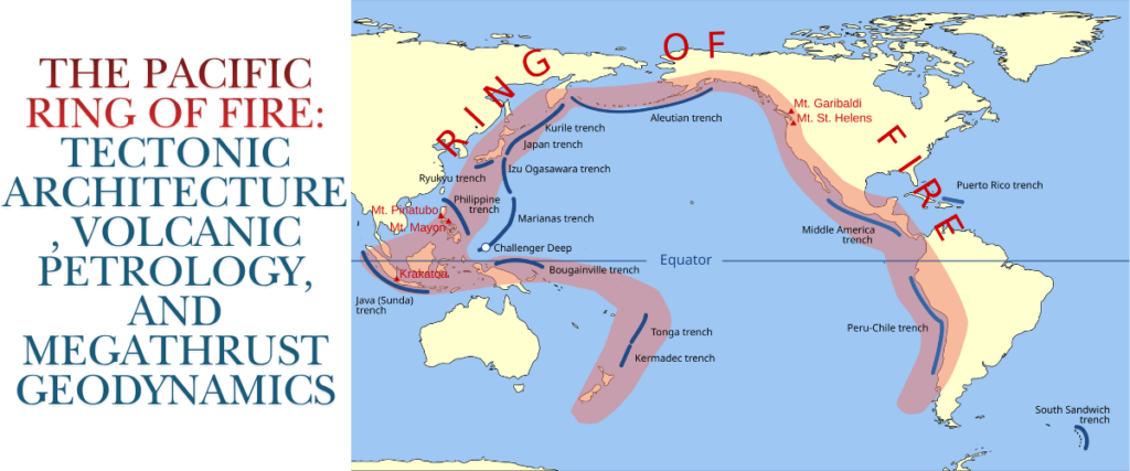
The Pacific Ring of Fire, also formally referred to as the Circum-Pacific Belt, represents the most geologically volatile and tectonically active expanse on Earth. Forming a massive horseshoe-shaped corridor that spans approximately 40,000 kilometres in length and up to 500 kilometres in width, this continuous series of oceanic trenches, volcanic arcs, back-arc basins, and tectonic plate boundaries delineates the perimeter of the Pacific Ocean basin1. The region accounts for unparalleled levels of seismic and volcanic activity, hosting between 750 and 915 active or dormant volcanoes, which constitutes roughly 75 percent of the world’s total active and dormant volcanic structures1.
More significantly, the Circum-Pacific Belt is the locus for approximately 90 percent of global seismic events, including 81 percent of the planet’s largest magnitude earthquakes1. The sheer scale of geological energy released along this perimeter dwarfs all other tectonic belts combined, such as the Alpide belt that stretches across the Mediterranean and Himalayas, which accounts for only 5 to 6 percent of global earthquakes4. The Ring of Fire is not a single, monolithic geological structure; rather, it is a highly complex mosaic of convergent and transform plate boundaries where massive lithospheric plates interact in a continuous cycle of creation, deformation, and destruction1. Understanding the geodynamics of the Ring of Fire requires a multifaceted approach, integrating the kinematics of tectonic plate motions, the deep-earth geochemistry of mantle melting, the paleoseismic records of megathrust earthquakes, and the deployment of advanced geodetic monitoring technologies designed to mitigate the profound hazards posed to populations inhabiting the Pacific Rim.
Geographic Boundaries and Tectonic Kinematics
The structural framework of the Ring of Fire is governed by the continuous collision and subduction of several oceanic plates beneath lighter continental or younger island-arc plates. This tectonic theatre is centred around the vast Pacific Plate, but is significantly influenced by a constellation of smaller, rapidly moving oceanic and micro-plates, including the Juan de Fuca, Cocos, Nazca, and Philippine Sea plates2.
Regional Tectonic Configurations
Along the eastern margin of the Pacific Rim, the architecture is defined by the subduction of the Nazca, Cocos, and Juan de Fuca plates beneath the massive continental lithospheres of the South American and North American plates1. The descent of the Nazca Plate forms the formidable Andes Mountains and the deep Peru-Chile Trench, driving the explosive volcanism of the Andean Volcanic Belt1. In Central America, the Cocos Plate is subducted beneath the Caribbean Plate, fueling the Central America Volcanic Arc1. Further north, the Juan de Fuca Plate dives beneath the North American Plate to create the Cascade Volcanic Arc, which extends from Northern California into British Columbia1. A notable exception to this continuous subduction occurs along the coast of California, where the Pacific Plate slides horizontally past the North American Plate along the San Andreas Fault—a transform boundary characterised by severe shallow earthquakes but an absence of active volcanism2.
The northern expanse of the Ring of Fire curves along the Aleutian Trench, where the northwestward-moving Pacific Plate subducts beneath the North American Plate, creating the extensive Aleutian Island Arc containing over 40 active volcanoes1. Moving down the western Pacific margin, the tectonic geometry becomes intensely complicated. The Pacific Plate plunges beneath the Okhotsk and Eurasian plates along the Kuril-Kamchatka and Japan trenches, driving extreme seismic activity and the highly active stratovolcanoes of the Japanese archipelago and Kamchatka Peninsula1.
Further south, the tectonic regime is dominated by the Philippine Sea Plate, a minor tectonic plate consisting of oceanic lithosphere that interacts with the Pacific, Sunda, and Eurasian plates9. The Pacific Plate subducts beneath the Philippine Sea Plate at the Mariana Trench, while the western edge of the Philippine Sea Plate subducts beneath the Eurasian Plate at the Philippine Trench1. The southwestern segment extends down through the complex microplates of Indonesia, Papua New Guinea, the Solomon Islands, Vanuatu, and Fiji, terminating in the Kermadec and Tonga trenches where the Pacific Plate subducts beneath the Indo-Australian Plate north of New Zealand1.
Debated Zones: The Sunda Arc and Antarctica
While the general boundaries of the Ring of Fire are well-established, geological consensus fractures over the inclusion of specific peripheral regions. The Sunda Arc, encompassing the western Indonesian islands of Sumatra and Java, is a prime example of this debate. The Sunda Arc represents the subduction of the Indo-Australian Plate beneath the Eurasian Plate at a velocity of 63 to 70 millimetres per year12. Because it sits at the transition zone between the Circum-Pacific Belt and the Alpide Belt, some geologists classify it entirely within the Alpide system6. However, others include it as a critical southwestern anchor of the Ring of Fire due to its extreme volcanic output, which includes the historical eruptions of Krakatoa and Mount Tambora, and its severe megathrust seismic potential, as evidenced by the 2004 Indian Ocean earthquake6.
Similarly, the inclusion of the Antarctic Peninsula and the South Shetland Islands remains contentious. Active subduction along the southern Pacific has largely ceased due to the presence of divergent boundaries like the Pacific-Antarctic Ridge, the East Pacific Rise, and the Chile Ridge, which interrupt the continuous convergent margins characteristic of the rest of the Ring of Fire1.
Tectonic Plate Velocities and Slab Pull
The dynamic nature of the Ring of Fire is intrinsically linked to the velocities at which these lithospheric plates travel across the asthenosphere. Plate motion is driven primarily by a mechanism known as “slab pull,” wherein the cold, dense, leading edge of a subducting oceanic plate sinks into the ductile mantle under its own weight, dragging the remainder of the tectonic plate behind it14.
| Tectonic Plate | Plate Type | Average Velocity | Key Direction and Geodynamic Characteristics |
| Pacific Plate | Oceanic | 7 to 10 cm/year | Moves northwestward; it is the fastest major plate due to extensive subduction boundaries and powerful slab pull, with localised regions exceeding 15 cm/year15. |
| Nazca Plate | Oceanic | Up to 16 cm/year | Exhibits extremely rapid eastward motion into the South American Plate, driving the intense deformation of the Andean orogeny17. |
| Indo-Australian Plate | Mixed | 6 to 7 cm/year | Moves northward, driving orthogonal and oblique convergence in the Sunda Arc and collision in the Himalayas16. |
| Juan de Fuca Plate | Oceanic | 3 to 4 cm/year | Subducting entirely beneath the Pacific Northwest along the Cascadia margin; poses severe megathrust hazards despite moderate velocity15. |
| North American Plate | Mixed | 1.5 to 2.5 cm/year | Slow westward drift; its interaction with the Pacific Plate forms major transform faults like the San Andreas15. |
| Eurasian Plate | Continental | 0.7 to 1.4 cm/year | The slowest major plate due to a distinct lack of subducting margins capable of generating efficient slab pull15. |
Paleogeographic Evolution of the Pacific Plate
The current configuration of the Ring of Fire is the result of hundreds of millions of years of lithospheric recycling. The Pacific Ocean basin itself is a remnant of the vast superocean Panthalassa, which once surrounded the supercontinent Pangea18. However, the Pacific Plate is relatively young compared to the ancient ocean basin it currently occupies.
The Birth of the Pacific Plate
Approximately 190 million years ago, during the Early Jurassic, the Pacific Plate emerged as a tiny microplate within the centre of the Panthalassa Ocean, far from the margins of the supercontinent1. It originated at a triple junction between three massive, ancient oceanic plates: the Izanagi Plate to the northwest, the Farallon Plate to the east, and the Phoenix Plate to the south11. Modern geodynamic reconstructions indicate that the plate formed because this triple junction had converted to an unstable transform-transform-transform configuration due to the development of a kink in one of the plate boundaries11.
This instability forced a massive plate boundary reorganisation, resulting in the formation of a stable triangular three-ridge spreading system. From this central nexus—an area known today as the “Pacific Triangle,” located just east of the Mariana Trench—the nascent Pacific Plate began to expand radially, continuously generating new basaltic crust11. As the Pacific Plate grew, it aggressively pushed the older Panthalassic plates toward the continental margins, initiating a long-term tectonic conveyor belt.
Subduction of the Izanagi and Farallon Plates
By 85 to 70 million years ago, the Izanagi Plate was forced northwestward, subducting entirely beneath eastern Asia. This process resulted in widespread arc volcanism and terrane accretion across Japan, Korea, and China1. The tectonic narrative became even more dramatic between 55 and 43 million years ago when the Izanagi-Pacific mid-ocean ridge intersected the East Asian subduction zone20. This ridge subduction event caused the complete detachment of the Izanagi slab as it descended into the mantle. The detachment created a margin-wide “slab window,” leading to a massive geodynamic reorganisation that altered the sub-Pacific mantle flow from a dominantly southward direction to a northward flow, fundamentally shifting the trajectory of the Pacific Plate20.
Simultaneously, the vast Farallon Plate was pushed eastward and systematically subducted beneath the North and South American plates. The consumption of the Farallon Plate was so extensive that by roughly 30 million years ago, the East Pacific Rise (the spreading centre between the Pacific and Farallon plates) collided with the North American trench19. This intersection initiated a tectonic transition from a convergent subduction boundary to a sliding transform boundary, giving birth to the San Andreas Fault system and physically separating the remnants of the Farallon Plate into the isolated Juan de Fuca, Cocos, and Nazca plates observed today8.
Slab Tearing and Window Formation
The geodynamic evolution of subduction zones frequently involves complex structural failures within the descending oceanic plates, particularly the phenomena of slab tearing and slab window formation. Slab tearing refers to the gradual propagation of a rupture within the subducting lithosphere, which significantly alters regional mantle flow patterns, surface topography, and magmatism23.
When lateral heterogeneities, such as mid-ocean ridges or buoyant continental blocks, enter a subduction zone, they resist downward motion. If the subduction obliquity angle is high (greater than 15 degrees) and the subducting plate is relatively young (less than 50 million years old), the initial slab break-off can transition into a gradually growing horizontal tear21. As the tear propagates, it opens a “slab window”—a gap in the downgoing plate that allows hot asthenosphere from beneath the slab to upwell into the mantle wedge21. This upwelling often triggers anomalous, geochemically distinct volcanism and alters the topographic uplift rates of the overriding plate. Over time, horizontal slab tearing can dynamically transform into vertical tearing, occasionally culminating in the formation of new transform faults on the subducting plate, a process that continues to shape the structural intricacies of the western and eastern Pacific margins21.
Subduction Dynamics, the Mantle Wedge, and Petrology
The primary geodynamic engine driving the Ring of Fire is the continuous process of subduction. Where dense, basaltic oceanic lithosphere converges with a more buoyant continental or younger oceanic plate, the older plate bends and sinks into the ductile asthenosphere at angles ranging between 25 and 75 degrees14. This creates a distinct zone of deep seismicity known as the Wadati-Benioff zone, which accurately outlines the trajectory of the descending slab deep into the mantle24.
Hydration and Serpentinization of the Forearc
The oceanic crust does not enter the subduction zone in a dry state. Over millions of years of exposure to seawater, the oceanic lithosphere undergoes extensive hydrothermal alteration. Seawater percolates through fractures, reacting with mantle peridotites to form hydrous minerals that store water within their crystal structures14. As the slab descends into the Earth’s interior, increasing temperatures and pressures trigger prograde metamorphic dehydration reactions. These reactions break down the hydrous minerals, liberating massive quantities of water and highly mobile, carbon-rich aqueous fluids into the overlying forearc mantle wedge25.
This massive influx of fluids heavily hydrates the ultramafic rocks at the base of the mantle wedge, triggering a profound chemical and structural transformation known as serpentinization. This process converts strong, dry mantle rocks (predominantly olivine and pyroxene) into weak serpentine minerals such as antigorite, chrysotile, and lizardite25. The serpentinized layer dramatically alters the mechanical behaviour of the subduction zone. Because serpentine is structurally weak, its presence at the base of the mantle wedge acts to mechanically decouple the descending slab from the overriding plate25.
This decoupling limits the downdip rupture extent of great megathrust earthquakes and heavily influences the occurrence of episodic tremor and slip (ETS) at the mantle wedge corner26. Thermodynamic modelling demonstrates that in warmer subduction zones, such as the Nankai Trough in southwestern Japan, the infiltration of fluids rich in aqueous carbon drives a phase transition in the mineral assemblage, shifting from serpentine-rich domains to talc and carbonate-rich assemblages at greater depths, further modifying the boundary between seismogenic and aseismic zones26.
Flux Melting and Magmagenesis
As the dehydrated fluids migrate further upward into the hotter regions of the mantle wedge, where ambient temperatures exceed 650 degrees Celsius, they fundamentally alter the thermodynamic state of the asthenospheric rock25. The introduction of water acts as a chemical flux, drastically lowering the solidus (the melting point) of the mantle peridotite by several hundred degrees29.
At a molecular level, the polar water molecules break the bridging oxygen bonds in the silicate (SiO4) tetrahedral chains of the mantle rock, a process formally termed “depolymerisation”30. This hydration melting, or flux melting, generates highly buoyant, silica-rich, and volatile-laden magma. Furthermore, this fluid transport selectively transfers Large Ion Lithophile Elements (LILEs) such as Rubidium, Strontium, Barium, and Lead, along with Light Rare Earth Elements (LREEs), into the melt, while leaving High Field Strength Elements (HFSEs) like Titanium, Niobium, and Tantalum locked within the descending slab29. As this newly formed magma ascends through the overriding continental or island-arc crust, it undergoes extensive fractional crystallisation and crustal assimilation, ultimately erupting at the surface to form the towering stratovolcanoes synonymous with the Ring of Fire2.
The Andesite Line: A Petrological Demarcation
A unifying geochemical and structural concept used to categorise the volcanism of the Pacific Rim is the “Andesite Line,” first proposed by New Zealand geologist Patrick Marshall in 191233. The Andesite Line represents a fundamental petrological boundary that traces the subduction trenches and distinguishes the geology of the deep ocean basin from that of the continental margins33.
Inside the Andesite Line—encompassing the central Pacific Basin and intra-plate hotspots like the Hawaiian Islands—the crust is exceptionally thin (5 to 10 kilometres) and fundamentally mafic. Volcanic activity here yields highly fluid basaltic magma characterised by low silica content (45 to 52 percent) and effusive, non-explosive eruptions that gradually build massive, gently sloping shield volcanoes32.
Conversely, the territory outside the Andesite Line marks the convergent boundaries of the Ring of Fire. Here, the crust is substantially thicker, reaching up to 70 kilometres, and is continental in origin. The magmas generated by flux melting in the subduction zones interact with this silica-rich continental crust, resulting in the eruption of intermediate to felsic rocks, predominantly andesite, dacite, and rhyolite33. Andesite, the volcanic rock for which the line is named, typically features a moderate to high silica content (55 to 70 percent) and is highly viscous32. This extreme viscosity traps expanding volcanic gases—primarily water vapour, carbon dioxide, and sulphur dioxide—during the magma’s ascent, leading to cataclysmic, explosive eruptions32. The resulting tephra, ash, and lava form the steep-sided, composite stratovolcanoes common to the Andes, the Cascades, Japan, and the Aleutians1. The Andesite Line, therefore, serves as a structural proxy for the limits of the Pacific Plate, effectively outlining the subduction mechanisms that continuously recycle basic oceanic lithosphere and distil it into buoyant, highly evolved continental crust35.
Environmental Byproducts: Volcanic Soils and Hydrothermal Vents
The relentless geologic activity of the Ring of Fire shapes more than just the topography of the continents; it plays a critical role in supporting diverse biological ecosystems through the creation of highly fertile soils and unique deep-sea habitats.
On land, the continuous deposition of volcanic ash and tephra leads to the formation of Andisols, a specific order of volcanic soils highly prized for agriculture36. Weathering of volcanic glass and ejecta rapidly produces short-range-order clays, predominantly allophane and imogolite36. These distinct clay minerals grant Andisols exceptional physical and chemical properties, including high water-holding capacity, high porosity, and the unique ability to sequester immense amounts of organic carbon36. Consequently, regions along the Ring of Fire, such as the slopes of Mount Fuji in Japan or the volcanic highlands of Indonesia, possess some of the most agriculturally productive land on Earth, capable of sustaining dense human populations despite the omnipresent volcanic hazard.
In the abyssal depths, the interaction between seawater and magma at spreading ridges and back-arc basins creates hydrothermal vents, commonly known as “black smokers.” Water seeps into the ocean floor, is superheated by shallow magma chambers, and is forcefully expelled back into the ocean, carrying dissolved minerals and highly toxic compounds like hydrogen sulfide38. Despite the extreme temperatures and pressures, these vents support complex ecosystems based on chemosynthesis, where specialised bacteria convert inorganic compounds into energy. However, these environments are facing emerging anthropogenic threats. For instance, hydrothermal vents in the Okinawa Trough and the Lau Basin are currently targeted for deep-sea mining operations aiming to harvest the rich deposits of copper, gold, and rare earth elements that precipitate from the vent fluids, an activity that scientists warn could irreparably damage these fragile, isolated ecosystems38.
Megathrust Seismicity and Stress Transfer
The rock-against-rock compression at the convergent boundaries of the Ring of Fire generates unparalleled tectonic stress. When the frictional resistance along these subduction interfaces—known as megathrust faults—is overcome, the ensuing rupture generates the most powerful and destructive earthquakes on the planet2.
The Mechanics of Megathrust Ruptures
The shallow portion of a subduction zone, generally extending from the trench down to depths of 25 to 30 kilometres, often becomes entirely “locked” due to immense friction between the overriding and subducting plates41. Decades, centuries, or even millennia of continuous plate convergence cause massive strain accumulation. This strain physically warps the overriding plate, dragging it downward and causing coastal uplift further inland. Eventually, the accumulated stress exceeds the mechanical strength of the fault. When the fault ruptures, the stored elastic strain is released violently, causing the leading edge of the overriding plate to snap forward and upward, while the inland coastal areas suddenly drop in elevation—a process known as coseismic subsidence41. The sudden vertical displacement of the seafloor displaces the entire water column above it, instantly generating a tsunami that can travel across ocean basins at speeds comparable to commercial jetliners41.
Megathrust earthquakes are uniquely capable of reaching Moment Magnitudes (Mw) of 9.0 and above. To comprehend this scale, it is crucial to recognise that the moment magnitude scale is logarithmic regarding energy release; a single whole number increase equates to approximately 32 times more energy released, while an increase of two numbers yields a massive 1,000-fold jump in explosive energy44. The Ring of Fire has hosted all recorded Mw 9.0+ events in modern history, including the 1952 Severo-Kurilsk earthquake (Mw 9.0), the 1960 Valdivia earthquake in Chile (Mw 9.4–9.6), the 1964 Alaska earthquake (Mw 9.2), the 2004 Indian Ocean earthquake off Sumatra (Mw 9.1–9.3), and the 2011 Tohoku earthquake in Japan (Mw 9.0–9.1)1.
Earthquake-Triggered Volcanism
The relationship between earthquakes and volcanism extends far beyond their shared tectonic setting; seismic activity can physically trigger volcanic eruptions. When a large megathrust or regional earthquake occurs, the permanent displacement of the crust alters the static Coulomb stress field in the surrounding lithosphere. A nearby magma chamber may experience sudden crustal relaxation, effectively decreasing the external confining pressure on the magma body. This “unclamping” reduces the threshold force required for the magma to fracture the overlying rock, thereby facilitating an eruption45. For example, studies suggest that during a progressive thrust sequence in central California, the 1983 Mw 6.7 Coalinga earthquake brought the subsequent 1983 Nuñez rupture significantly closer to Coulomb failure by transferring static stress across the regional fault network46.
Additionally, dynamic stress—the transient, intense shaking from passing seismic waves—can perturb magmatic systems hundreds or thousands of kilometres away. Similar to vigorously shaking a carbonated beverage, passing seismic waves can induce rapid bubble nucleation, density shifts, and the exsolution of dissolved gases within a magma chamber, sharply driving up internal pressure45. While it is generally accepted that a volcano must already be in a critical state—poised to erupt, with sufficient eruptible magma and internal pressure—to be triggered by a distant earthquake, empirical evidence shows that regions experiencing Mw 9.0+ earthquakes often see a distinct uptick in local volcanic eruptions in the subsequent weeks and months, confirming the profound interconnectedness of tectonic and magmatic systems45.
Paleoseismology and the Cascadia Subduction Zone
One of the most intensely studied and critical segments of the Ring of Fire is the Cascadia Subduction Zone (CSZ), extending roughly 1,000 kilometres from Cape Mendocino in northern California to Vancouver Island in British Columbia7. The CSZ represents a unique hazard paradigm: despite a total lack of major instrumentally recorded megathrust earthquakes in modern history, comprehensive geological evidence points to a terrifying legacy of recurring catastrophic ruptures.
The 1700 Megathrust Earthquake
Through a brilliant synthesis of terrestrial paleoseismology, dendrochronology, indigenous oral history, and international historical archives, geoscientists have determined that the last full-margin rupture of the CSZ occurred on January 26, 17007. The event, estimated at Mw 8.7 to 9.2, involved up to 20 meters of slip along the fault and triggered a massive ocean-spanning tsunami7. Because the indigenous populations of the Pacific Northwest possessed rich oral traditions documenting the catastrophic shaking and flooding, but no written calendars to provide an exact date, the precise timing of the quake was unravelled by cross-referencing coastal subsidence data with Japanese historical records. In coastal Japanese towns like Kuwagasaki, Otsuchi, and Tsugaruishi, local authorities meticulously documented an “orphan tsunami”—a destructive wave arriving without a preceding felt earthquake—that struck on the 8th and 9th days of the 12th month of the Genroku 12 era (January 27 and 28, 1700)7. Back-calculating the tsunami’s travel time across the Pacific pinpointed the CSZ rupture to approximately 9:00 PM Pacific Time on January 267.
In North America, undeniable evidence of the 1700 earthquake is preserved in “ghost forests”—stands of western red cedar and Sitka spruce that were instantly killed when the coastal land abruptly subsided by over a meter, plunging their root systems into the saline intertidal zone43. Dendrochronological analysis of these remarkably preserved stumps confirms that the outermost tree rings formed during the 1699 growing season, proving conclusively that the trees died in the winter of 1699–170051.
Marine Turbidite Paleoseismology
To calculate the recurrence interval of these megathrust events over a much longer timeframe, geologists rely heavily on marine turbidites—sedimentary deposits left by underwater avalanches, or turbidity currents, triggered by intense seismic shaking53. The Cascadia Basin is uniquely suited for turbidite paleoseismology due to its extensive, interconnected submarine canyon systems53. By analysing deep-sea core samples from the abyssal plain, researchers have identified 41 distinct turbidite events over the past 10,000 years53.
Correlation of these turbidites is a complex process. Scientists utilise radiocarbon (14C) dating of foraminifera found directly beneath individual turbidites to construct Bayesian age-depth models56. To match specific earthquake events across different submarine canyons, researchers employ dynamic time warping of magnetic susceptibility logs to evaluate correlation strength, ensuring that variations in sedimentology are accurately matched54. Detailed stratigraphic analysis reveals fascinating interconnected relationships; for example, specific turbidite successions feature a distinctive thick, inverted “doublet” stratigraphy in the Noyo Channel along the northern San Andreas fault. These doublets indicate that major earthquakes on the San Andreas fault have historically triggered turbidity currents in the southernmost Cascadia subduction zone, and vice versa, pointing to an intimate stress-triggering relationship between the two distinct fault systems57.
The synthesis of this 10,000-year turbidite record indicates that the CSZ experiences two primary rupture modes: massive, full-margin ruptures occurring roughly every 500 years, and smaller, segmented ruptures concentrated in the southern Cascadia region with a much shorter recurrence interval of approximately 240 years53. High-resolution bathymetry and sediment core analysis also demonstrate that repeated megathrust earthquakes locally deform and uplift the accretionary wedge, destabilising sediments into asymmetrical folds that eventually collapse during strong shaking to form these extensive mass-transport deposits56. This implies that the CSZ is deeply integrated into a dynamic, bottom-up sediment recycling system, allowing scientists to track prehistoric seismic cycles with unprecedented precision56.
Technological Innovations in Hazard Monitoring
Given the immense threat posed by the Ring of Fire to global populations and infrastructure, massive investments have been made in geodetic, seismic, and oceanic monitoring systems. These tools are absolutely critical for early warning, hazard mitigation, and understanding deep-earth geodynamics in real-time.
DART Tsunami Early Warning Systems
To mitigate the catastrophic impact of tsunamis, the National Oceanic and Atmospheric Administration (NOAA) developed the Deep-ocean Assessment and Reporting of Tsunamis (DART) buoy network58. Originally deployed in 1995 and heavily expanded following the 2004 Indian Ocean tsunami, the DART II and the newer DART ETD (Easy To Deploy) systems rely on highly sensitive Bottom Pressure Recorders (BPRs) anchored directly to the seafloor60.
The BPR utilises a resonant quartz crystal strain gauge equipped with a Bourdon tube force collector61. When mathematically compensated for temperature variations—which affect water density and thus absolute pressure—the sensor achieves a remarkable pressure resolution equivalent to just 1 millimetre of water depth, even when deployed at abyssal depths exceeding 6,000 meters61. Data is transmitted from the BPR via an acoustic modem link to a moored surface buoy, which then relays the information via the Iridium commercial satellite network to Tsunami Warning Centers61.
The DART II system operates in two distinct functional modes. In “Standard Mode,” it logs seafloor pressure every 15 minutes and transmits data hourly, ensuring routine monitoring and quality assurance of the system’s health61. However, if the internal software detects a rapid pressure anomaly indicative of a passing tsunami wave, or if the buoy is manually pinged by an onshore warning centre, the system instantly switches to “Event Mode.” In Event Mode, the BPR transmits high-resolution data at 15-second intervals, providing near real-time wave height parameters essential for running numerical forecasting models, which greatly reduces the incidence of expensive and panic-inducing false alarms59.
InSAR and Geodetic Strain Measurement
Monitoring the microscopic deformation of the Earth’s crust before, during, and after volcanic eruptions or earthquakes is now heavily reliant on Interferometric Synthetic Aperture Radar (InSAR) and Global Positioning System (GPS) networks63.
InSAR relies on satellite-mounted radar systems that actively emit microwave pulses to the Earth’s surface and record the backscattered signal’s amplitude and phase64. By combining or “interfering” the phase information of two radar images taken of the same geographic area at different times, geophysicists can create an interferogram—a visual map of interference fringes that represent the relative line-of-sight (LOS) displacement of the ground surface64. Depending on the radar wavelength utilised by the satellite (C-band sensors at 4–8 cm, or L-band sensors at 15–30 cm), InSAR can measure surface inflation or subsidence with sub-centimetre accuracy over vast, inaccessible regions63. This has become an indispensable tool in volcanology for detecting the subtle swelling of a volcano’s flanks as magma accumulates in a subsurface reservoir64. While atmospheric delay anomalies (fluctuations in water vapour) can occasionally obscure data by creating false phase shifts, advanced multi-temporal processing techniques, such as stacking and least squares inversion, successfully filter out this noise to reveal true, transient deformation patterns63.
Simultaneously, dense networks of continuous GPS/GNSS stations measure interseismic tectonic strain accumulation along the Ring of Fire’s active fault systems65. By tracking the microscopic millimetre-per-year movements of bedrock, geophysicists can construct complex viscoelastic block models. These models map precisely where megathrust interfaces are strongly locked by friction, and where they are creeping aseismically42. Using geometries provided by frameworks like the Uniform California Earthquake Rupture Forecast (UCERF3), geophysicists invert GPS velocity data to estimate highly specific fault slip rates. Current models show the San Andreas fault slipping at rates between 19 and 28 millimetres per year depending on the specific segment, while the western Garlock fault exhibits a surprisingly low slip rate of just 1.7 millimetres per year71. These GPS-derived strain maps are absolutely critical for long-term probabilistic seismic hazard assessments, allowing emergency management authorities to isolate the exact fault segments capable of generating the next catastrophic rupture72.
Geothermal Energy and the Tectonic Dividend
Beyond the severe hazards of volcanism and seismicity, the intense thermal flux characterising the Ring of Fire provides a tremendous economic and environmental opportunity for sustainable power generation39. The abundance of shallow magma chambers and the pervasive fracturing of crustal rocks create ideal conditions for extensive hydrothermal circulation. Surface water percolates deep into the crust, is superheated by the tectonic environment, and rises back toward the surface, providing a ubiquitous baseline energy source that can be tapped for geothermal power39.
By the end of 2025, global installed geothermal power capacity reached 17,173 Megawatts (MW), with production heavily dominated by nations situated directly on the Pacific Ring of Fire75. Countries exploit these resources using a variety of plant designs. While traditional dry steam and flash steam plants are common in high-temperature reservoirs, the industry is increasingly turning toward Binary Organic Rankine Cycle (ORC) and Kalina Cycle power plants. These binary plants utilise a secondary organic working fluid with a lower boiling point than water to extract heat from lower-temperature geothermal reservoirs, vastly expanding the geographic viability of geothermal energy77.
Leading Geothermal Producers (2025 Installed Capacity)
| Country | 2025 Installed Capacity (MW) | Primary Geodynamic Context |
| United States | 3,953 | Driven by the San Andreas transform margin, Cascade Volcanic Arc, and Basin & Range extension. The U.S. remains the undisputed global leader75. |
| Indonesia | 2,742 | Driven by Sunda Arc subduction. Indonesia is currently the fastest-growing large geothermal market globally, adding massive capacity through projects like Ijen and Lumut Balai75. |
| Philippines | 2,034 | Driven by the Philippine Mobile Belt and active subduction boundaries. The Philippines heavily relies on geothermal power for baseline grid stability9. |
| Türkiye | 1,797 | Driven by complex Mediterranean tectonics. Türkiye is Europe’s largest geothermal producer, utilising revised feed-in tariffs to spur development75. |
| New Zealand | 1,259 | Driven by the Taupō Volcanic Zone. New Zealand recently expanded capacity through binary-cycle units designed to reinject all carbon dioxide emissions back into the reservoir75. |
| Mexico | 976 | Driven by the Trans-Mexican Volcanic Belt and tectonic extension1. |
| Japan | 607 | Extreme volcanic density driven by triple plate subduction (Pacific, Philippine, Eurasian plates). Growth remains steady but constrained by regulatory hurdles9. |
While conventional geothermal capacity growth has historically been constrained to regions with naturally occurring fluid and permeability, Ring of Fire nations and innovators in the United States are pioneering Enhanced Geothermal Systems (EGS) and Advanced Geothermal Systems (AGS). Companies like Fervo Energy and Eavor are adapting horizontal drilling and fibre-optic sensor technologies from the oil and gas industry to artificially inject high-pressure fluids and hydraulically fracture hot, impermeable bedrock76. By creating their own fluid pathways, these closed-loop and enhanced systems promise to exponentially expand the exploitable geothermal footprint. This technological leap effectively decouples power generation from the immediate vicinity of natural hot springs, promising to transform the tectonic heat of the Pacific Rim into a universally accessible, zero-carbon energy source76.
Conclusion
The Pacific Ring of Fire is the Earth’s preeminent tectonic laboratory, an interlocking network of massive subduction zones and transform faults that actively shapes the lithosphere, atmosphere, and biosphere. By driving the relentless subduction of ancient oceanic plates like the Farallon and Izanagi, the Circum-Pacific Belt has continually recycled terrestrial matter. It utilises the complex geochemistry of forearc serpentinization and flux melting to distil basic ocean floor into the buoyant, silica-rich andesitic rocks that construct our continents. While this geodynamic engine brings immense benefits—ranging from the generation of agriculturally rich Andisols to the provisioning of vast, untapped geothermal energy reserves—it inherently subjects the Pacific Rim to catastrophic natural hazards. The continual, inevitable accumulation and release of tectonic strain dictates that megathrust earthquakes and explosive stratovolcanic eruptions will remain a permanent fixture of the region’s future. However, through the rigorous integration of marine turbidite paleoseismology, deep-ocean DART monitoring, and advanced satellite geodesy like InSAR and GPS strain mapping, human civilisation is steadily advancing its capacity to forecast, understand, and mitigate the raw geologic forces operating along the Ring of Fire.
Disclaimer
This report is provided for informational and educational purposes only. It is not intended to serve as a substitute for official safety directives, early warning alerts, or hazard mitigation guidance from designated emergency management agencies regarding earthquakes, tsunamis, or volcanic eruptions.
Referenes
- Ring of Fire – Wikipedia, https://en.wikipedia.org/wiki/Ring_of_Fire
- Ring of Fire | Definition, Map, & Facts | Britannica, https://www.britannica.com/place/Ring-of-Fire
- The Ring of Fire – ArcGIS StoryMaps, https://storymaps.arcgis.com/stories/d4ac52a44a3c4ba898ad2ee3344f450b
- Reading: The Ring of Fire | Geology – Lumen Learning, https://courses.lumenlearning.com/geo/chapter/reading-the-ring-of-fire-2/
- ringoffire.gif | U.S. Geological Survey – USGS.gov, https://www.usgs.gov/media/images/ringoffiregif
- Pacific Ring Of Fire – World Atlas, https://www.worldatlas.com/geography/pacific-ring-of-fire.html
- 1700 Cascadia earthquake – Wikipedia, https://en.wikipedia.org/wiki/1700_Cascadia_earthquake
- Transform Plate Boundaries – Geology (U.S. National Park Service), https://www.nps.gov/subjects/geology/plate-tectonics-transform-plate-boundaries.htm
- Philippine Sea plate – Wikipedia, https://en.wikipedia.org/wiki/Philippine_Sea_plate
- Seismicity of the Earth 1900-2012 Philippine Sea plate and vicinity, https://pubs.usgs.gov/publication/ofr20101083M
- Pacific plate – Wikipedia, https://en.wikipedia.org/wiki/Pacific_plate
- The Lesser Sunda Islands – Seismic Atlas of SE Asian Basins, http://geoseismic-seasia.blogspot.com/2013/06/the-lesser-sunda-islands.html
- Sunda Arc – Wikipedia, https://en.wikipedia.org/wiki/Sunda_Arc
- Subduction – Wikipedia, https://en.wikipedia.org/wiki/Subduction
- How Fast Do Tectonic Plates Move – Geology In, https://www.geologyin.com/2025/03/how-fast-do-tectonic-plates-move.html
- How Do Tectonic Plates Move? – World Atlas, https://www.worldatlas.com/geography/how-do-tectonic-plates-move-2026.html
- Plate tectonics – Wikipedia, https://en.wikipedia.org/wiki/Plate_tectonics
- On the enigmatic birth of the Pacific Plate within the Panthalassa Ocean – PubMed, https://pubmed.ncbi.nlm.nih.gov/29713683/
- The Plate Tectonic Evolution of the Pacific Ocean – Paleomap Project, http://www.scotese.com/pacifanim.htm
- Ridge subduction sparked reorganization of the Pacific plate-mantle system 60-50 million years ago – EarthByte, https://www.earthbyte.org/Resources/Pdf/Seton_etal_2015_ridge_subduction_Pacific_reorganisation.pdf
- Slab tearing and slab window facilitated by the subduction of an active… – ResearchGate, https://www.researchgate.net/figure/Slab-tearing-and-slab-window-facilitated-by-the-subduction-of-an-active-spreading-ridge_fig4_406488425
- Plate Tectonic History of the North Pacific Ocean, animation, https://animations.geol.ucsb.edu/2_infopgs/IP3RegTect/dNoPacific.html
- How does slab tearing evolve? – EGU Blogs – European Geosciences Union, https://blogs.egu.eu/divisions/gd/2023/03/29/how-does-slab-tearing-evolve/
- At what depth do earthquakes occur? What is the significance of the depth? – USGS.gov, https://www.usgs.gov/faqs/what-depth-do-earthquakes-occur-what-significance-depth
- Serpentinization of the forearc mantle wedge in subduction zones: revisiting Roy D. Hyndman’s seminal – GeoScienceWorld, https://pubs.geoscienceworld.org/csp/cjes/article-pdf/62/4/758/7167103/cjes-2024-0082.pdf
- Subducted carbon weakens the forearc mantle wedge in a warm subduction zone – PMC, https://pmc.ncbi.nlm.nih.gov/articles/PMC11347577/
- Geochemical Evolution and Tectonic Setting of Neoproterozoic Serpentinites from the Bou Azzer Ophiolite, Morocco: Evidence for Subduction-Related Mantle Wedge Processes – Preprints.org, https://www.preprints.org/manuscript/202510.0613
- Serpentinization of the forearc mantle wedge in subduction zones: revisiting Roy D. Hyndman’s seminal contributions 25 years later – Canadian Science Publishing, https://cdnsciencepub.com/doi/10.1139/cjes-2024-0082
- Experimental evidence for fluid-induced melting in subduction zones, https://www.geochemicalperspectivesletters.org/article1925/
- Could somebody please explain to me what flux melting is, and how it relates to subduction? : r/geology – Reddit, https://www.reddit.com/r/geology/comments/g5cs9/could_somebody_please_explain_to_me_what_flux/
- Subduction zone geochemistry – Geoscience Frontiers, http://www.geosciencefrontiers.com/article/doi/10.1016/j.gsf.2019.02.003
- Andesite: Igneous Rock – Pictures, Definition & More – Geology.com, https://geology.com/rocks/andesite.shtml
- Andesite line – Wikipedia, https://en.wikipedia.org/wiki/Andesite_line
- The Andesite Line | Volcanoes – Te Ara Encyclopedia of New Zealand, https://teara.govt.nz/en/map/8696/the-andesite-line
- Andesite Line – GKToday, https://www.gktoday.in/andesite-line/
- Volcanic Soils – WUR eDepot, https://edepot.wur.nl/484591
- Characteristics of Andisols Developed from Andesitic and Basaltic Volcanic Ash in Different Agro-Climatic Zones – MDPI, https://www.mdpi.com/2571-8789/6/4/78
- Mining at key hydrothermal vents could endanger species at distant sites, https://www.oist.jp/news-center/news/2023/2/14/mining-key-hydrothermal-vents-could-endanger-species-distant-sites
- Ring of Fire | Earth and Atmospheric Sciences | Research Starters – EBSCO, https://www.ebsco.com/research-starters/earth-and-atmospheric-sciences/ring-fire
- Ridge subduction and porphyry copper-gold mineralization: An overview – ResearchGate, https://www.researchgate.net/publication/226163124_Ridge_subduction_and_porphyry_copper-gold_mineralization_An_overview
- Introduction to Subduction Zones: Amazing Events in Subduction Zones – USGS.gov, https://www.usgs.gov/special-topics/subduction-zone-science/science/introduction-subduction-zones-amazing-events
- Implications of the earthquake cycle for inferring fault locking on the Cascadia megathrust, https://www.usgs.gov/publications/implications-earthquake-cycle-inferring-fault-locking-cascadia-megathrust
- The 1700 Cascadia Megathrust Earthquake and the Future of Cascadia Margin | EARTH 107: Coastal Processes, Hazards and Society, https://courses.ems.psu.edu/earth107/node/1614
- JetStream Max: Plate Tectonics and Earthquakes | National Oceanic and Atmospheric Administration – NOAA, https://www.noaa.gov/jetstream/tsunamis/tsunami-generation-earthquakes/jetstream-max-plate-tectonics-and-earthquakes
- Volcano Watch — Can earthquakes trigger volcanic eruptions? – USGS.gov, https://www.usgs.gov/observatories/hvo/news/volcano-watch-can-earthquakes-trigger-volcanic-eruptions
- Stress triggering in thrust and subduction earthquakes and stress interaction between the southern San Andreas and nearby thrust and strike-slip faults | U.S. Geological Survey – USGS.gov, https://www.usgs.gov/publications/stress-triggering-thrust-and-subduction-earthquakes-and-stress-interaction-between
- Can earthquakes trigger volcanic eruptions? | U.S. Geological Survey – USGS.gov, https://www.usgs.gov/faqs/can-earthquakes-trigger-volcanic-eruptions
- Cascadia | U.S. Geological Survey – USGS.gov, https://www.usgs.gov/special-topics/subduction-zone-science/science/cascadia
- Rethinking turbidite paleoseismology along the Cascadia subduction zone – ResearchGate, https://www.researchgate.net/publication/270688411_Rethinking_turbidite_paleoseismology_along_the_Cascadia_subduction_zone
- (PDF) The 1700 Cascadia Megathrust Earthquake: A Geological Ghost Resurrected by Science and Story – ResearchGate, https://www.researchgate.net/publication/391953271_The_1700_Cascadia_Megathrust_Earthquake_A_Geological_Ghost_Resurrected_by_Science_and_Story
- M 9.0 – The 1700 Cascadia Earthquake, https://earthquake.usgs.gov/earthquakes/eventpage/official17000127050000000/impact
- Studying Tsunami Sands to Better Understand the 1700 Cascadia Earthquake | U.S. Geological Survey – USGS.gov, https://www.usgs.gov/programs/cmhrp/news/studying-tsunami-sands-better-understand-1700-cascadia-earthquake
- Turbidite Event History—Methods and Implications for Holocene Paleoseismicity of the Cascadia Subduction Zone – Find People, https://people.wou.edu/~taylors/g473/Goldfinger_etal_2011_excerpt_reading.pdf
- Turbidite correlation for paleoseismology | GSA Bulletin – GeoScienceWorld, https://pubs.geoscienceworld.org/gsa/gsabulletin/article/137/1-2/29/645040/Turbidite-correlation-for-paleoseismology
- Turbidite event history—Methods and implications for Holocene paleoseismicity of the Cascadia subduction zone – USGS Publications Warehouse, https://pubs.usgs.gov/publication/pp1661F
- Deep-ocean sediments chronicle thousands of years of Cascadia megathrust earthquakes, https://watchers.news/epicenter/deep-ocean-sediments-chronicle-thousands-of-years-of-cascadia-megathrust-earthquakes/
- Unravelling the dance of earthquakes: Evidence of partial synchronization of the northern San Andreas fault and Cascadia megathrust | Geosphere | GeoScienceWorld, https://pubs.geoscienceworld.org/gsa/geosphere/article/21/6/1132/661517/Unravelling-the-dance-of-earthquakes-Evidence-of
- Tsunami Detection, https://www.tsunami.noaa.gov/pmel-theme/tsunami-detection
- Deep-ocean Assessment and Reporting of Tsunamis (DART), https://nctr.pmel.noaa.gov/dart_report1998.html
- About DART (Deep-ocean Assessment and Reporting of Tsunamis), https://nctr.pmel.noaa.gov/Dart/about-dart.html
- Deep-ocean Assessment and Reporting of Tsunamis – Wikipedia, https://en.wikipedia.org/wiki/Deep-ocean_Assessment_and_Reporting_of_Tsunamis
- DART II Deep Ocean Assessment and Reporting of Tsunami’s, https://mm0zif.radio/current/2025/08/dart-ii-deep-ocean-assessment-and-reporting-of-tsunamis/
- Full article: Monitoring and characterizing natural hazards with satellite InSAR imagery – Taylor & Francis, https://www.tandfonline.com/doi/full/10.1080/19475681003700914
- InSAR—Satellite-based technique captures overall deformation “picture” – USGS.gov, https://www.usgs.gov/programs/VHP/insar-satellite-based-technique-captures-overall-deformation-picture
- Strain Rate Patterns from Dense GPS Networks – Digital Commons @ USF – University of South Florida, https://digitalcommons.usf.edu/cgi/viewcontent.cgi?article=3199&context=geo_facpub
- Interferometric Synthetic Aperture Radar – Geoscience Australia, https://www.ga.gov.au/scientific-topics/positioning-navigation/positioning-australia/geodesy/geodetic-techniques/interferometric-synthetic-aperture-radar
- Monitoring ground displacement in the Aegean region (Hellenic Arc)-based InSAR analysis – SPIE Digital Library, https://www.spiedigitallibrary.org/conference-proceedings-of-spie/13670/1367016/Monitoring-ground-displacement-in-the-Aegean-regionHellenic-Arc-based-InSAR/10.1117/12.3070084.full
- Volcano Monitoring: Using InSAR to see changes in volcano shape – IRIS, https://www.iris.edu/hq/inclass/animation/volcano_monitoring_using_insar_to_see_changes_in_volcano_shape
- Using strain rates to forecast seismic hazards – USGS Publications Warehouse, https://pubs.usgs.gov/publication/70187494
- Mechanical deformation model of the western United States instantaneous strain-rate field, https://pubs.usgs.gov/publication/70028377
- A fault-based model for crustal deformation, fault slip-rates and off-fault strain rate in California – USGS Publications Warehouse, https://pubs.usgs.gov/publication/70160311
- A new map of strain across the western US using GPS data – UNAVCO.org, https://www.unavco.org/news/a-new-map-of-strain-across-the-western-us-using-gps-data%EF%BF%BC/
- A fault‐based model for crustal deformation in the western United States based on a combined inversion of GPS and geologic inputs – USGS Publications Warehouse, https://pubs.usgs.gov/publication/70191363
- Geothermal’s Global Surge: The Top Countries and the Tech Behind the Rise | Utah FORGE, https://utahforge.com/geothermals-global-surge-the-top-countries-and-the-tech-behind-the-rise/
- Global Top 10 Geothermal Power Countries at Year-End 2025, https://www.thinkgeoenergy.com/global-top-10-geothermal-power-countries-at-year-end-2025/
- Global Top 10 Geothermal Power Countries at Year-End 2025 | Utah FORGE, https://utahforge.com/utah_forge_news/global-top-10-geothermal-power-countries-2025/
- Worldwide geothermal power (2024) | Research Communities by Springer Nature, https://communities.springernature.com/posts/worldwide-geothermal-power-2024
- GSR 2025 | Geothermal – REN21, https://www.ren21.net/gsr-2025/technologies/geothermal/
- 2025 U.S. Geothermal Market Report | NLR – National Laboratory of the Rockies, https://www.nlr.gov/geothermal/2025-us-geothermal-market-report
- Geothermal Energy Become Bigger in 2026: Why Now – ICE Global News, https://www.iceglobalnews.com/geothermal-energy-become-bigger-2026/
- The Pacific Ring of Fire, with trenches marked with blue lines, https://en.wikipedia.org/wiki/Ring_of_Fire#/media/File:Pacific_Ring_of_Fire.svg