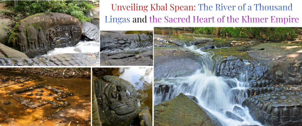
Deep within the verdant embrace of the Phnom Kulen National Park in northwestern Cambodia lies an archaeological marvel that defies traditional architectural boundaries. Kbal Spean, widely known as the “River of a Thousand Lingas,” is not a soaring temple of laterite and sandstone reaching toward the heavens. Instead, it is a monument carved directly into the living bedrock of a flowing river1. Located in the Banteay Srei district of Siem Reap Province, approximately fifty kilometres northeast of the monumental Angkor Wat, Kbal Spean represents a profound synthesis of natural geography, hydraulic engineering, and deep religious devotion2.
For the ancient Khmer, water was not merely a resource for agricultural survival; it was a sacred substance that needed to be blessed before it could nourish the empire. By carving thousands of religious icons into the riverbed, the Khmer essentially constructed a divine water purification and fertilisation system3. As the river waters flowed over the phallic symbols of Shiva and the creator gods of the Hindu pantheon, the water was believed to absorb cosmic energy, carrying these blessings downstream to the vast rice plains and grand reservoirs of the Angkorian capital1.
This comprehensive report explores Kbal Spean from multiple vantage points. It analyses the site’s underlying geological and climatic framework, traces the deep mythological and cosmological meaning behind its intricate iconography, and positions its role within the broader hydraulic network of the ancient Khmer Empire. Furthermore, the analysis details the romantic and delayed history of its modern discovery, the epigraphic records left by its architects, and its contemporary status as both a heavily protected archaeological zone and a sanctuary for Cambodia’s endangered biodiversity.
The Geomorphology and Climate of the Sacred Mountain
To comprehend the engineering and spiritual significance of Kbal Spean, one must first analyse its geological and environmental context. The site is situated on the Kulen Mountains (Phnom Kulen), a sandstone plateau that rises sharply from the surrounding floodplains to an elevation ranging from 56 to 498 meters above sea level4.
Sandstone Foundations and Topography
The Kulen Plateau rests upon an ancient block of continental crust that has remained relatively stable since the Jurassic Period, an epoch spanning over 150 million years5. Large areas of this region were covered by an inland sea during the upper Mesozoic Era, resulting in the deposition of thick red-bed sandstones and evaporites6. This foundational sandstone is the very medium utilised by Khmer artisans; the name “Kbal Spean” itself translates from Khmer as “Bridge Head,” referencing a natural sandstone archway where the river has tunnelled through a massive boulder, creating a natural geological bridge over the water2.
The pedological composition of the Phnom Kulen National Park area is characterised by highly weathered and heavily leached soils. Studies indicate that Dystric Leptosol covers approximately eighty-five percent of the total area, while Haplic Acrisol accounts for fourteen percent5. These soils are typically susceptible to severe erosion, are deficient in essential nutrients such as phosphorus, calcium, and potassium, and often suffer from toxic aluminium build-up, rendering them generally infertile for large-scale agriculture7. This geological reality had profound implications for the Khmer Empire. Because the plateau could not support intensive rice cultivation, the early capital was eventually forced to relocate to the nutrient-rich floodplains below, transforming the Kulen plateau from a residential centre into a remote, sacred watershed8.
Hydrology and the Monsoonal Pulse
The Kulen plateau acts as a massive natural aquifer, capturing the intense monsoon rains and channelling them into the primary river systems of the region: the Siem Reap, the Puok, and the Roluos rivers9. The Stung Kbal Spean river is a major tributary that cuts directly through these sandstone formations2. Eventually, this river merges to form the Siem Reap River, which flows southward, bisecting the ancient city of Angkor before emptying into the massive Tonle Sap Lake2.
The regional climate is defined by intense seasonal fluctuations. Meteorological records indicate an average annual temperature of 28 degrees Celsius, oscillating between a minimum of 25 degrees Celsius in the rainy season and a maximum of 34 degrees Celsius in the dry season5. The area receives an annual average rainfall of 1,580 to 2,050 millimeters5. The visibility and aesthetic impact of Kbal Spean are entirely dictated by this seasonal hydrology. During the peak of the monsoon season, the river swells, and the rushing waters obscure the majority of the intricate bedrock carvings2. As the dry season approaches, the water level recedes to a pristine, shallow flow—often just five centimetres deep—revealing the magnificent grid of carved stones beneath12. It is this precise interplay between the static stone carvings and the ephemeral, moving water that defines the site’s unique architectural genius14.
The Genesis of the Empire: Mahendraparvata and the LiDAR Revolution
To understand the religious reverence afforded to Kbal Spean in the eleventh century, one must examine the origins of the Khmer Empire on the very same mountain plateau over two centuries prior. Long before the kings of the classical Angkor period carved the riverbed, Phnom Kulen was known as Mahendraparvata, the “Mountain of the Great Indra”9.
Jayavarman II and the Devaraja Cult
According to the Sdok Kak Thom inscription, a crucial epigraphic text, it was on this sacred plateau in the year 802 CE that King Jayavarman II declared the independence of the Khmer people from the suzerainty of “Java”9. Upon establishing his capital at Mahendraparvata, Jayavarman II invited the Brahmin priest Hiranyadama from the region of Janapada to conduct a transformative religious rite16.
Utilising four sacred Tantric texts—the Vinasikha, Nayottara, Sammoha, and Sirascheda—the Brahmin initiated Jayavarman II as the universal monarch, or cakravartin16. This ceremony instituted the Devaraja (God-King) cult, a foundational political and religious ideology that inextricably linked the absolute authority of the monarch with the divine, generative power of the Hindu god Shiva9. Mahendraparvata thus served as the ideological incubator for the Khmer Empire, embedding the Kulen plateau into the sacred geography of the nation8.
Uncovering the Grid City
For many decades, historians operating with limited ground-survey data assumed that Mahendraparvata was merely a small, loosely connected series of religious shrines utilised temporarily by the early court3. This assumption was thoroughly dismantled following extensive remote sensing campaigns. In 2012 and 2015, the Cambodian Archaeological Lidar Initiative (CALI), led by archaeologists Jean-Baptiste Chevance and Damian Evans, utilised Light Detection and Ranging (LiDAR) technology to map the Phnom Kulen plateau from the air9. The airborne lasers successfully penetrated the dense jungle canopy, revealing the precise topographic anomalies of the ancient forest floor20.
The LiDAR data unveiled a massive, densely populated urban grid covering 40 to 50 square kilometers9. It revealed an elaborate network of major avenues aligned to cardinal directions, dividing the city into distinct blocks9. These city blocks contained hundreds of individual mounds, shrines, and a sophisticated hydraulic management system featuring dams engineered to block river valleys and create reservoirs20.
| Key Archaeological Features of Mahendraparvata | Description and Significance |
| Prasat Rong Chen | The first pyramid or “temple-mountain” constructed in the Angkorian world. Built on the highest point of the southern plateau, its tiered laterite structure served as the architectural prototype for later monuments like the Baphuon and Angkor Wat9. |
| The Royal Palace (Banteay) | A rectangular compound identified in 2009, confirming the physical presence of King Jayavarman II’s administrative court in the early ninth century9. |
| Thnal Srae Thbong & Thnal Mrech Dikes | Massive earthen dikes, including the one-kilometre-long Thnal Mrech, designed to form a large, albeit unfinished, reservoir (baray) to manage the monsoon waters9. |
| Urban Grid Network | A centralised urban network of oriented earthen dikes acting as major axes, representing the first large-scale, formally planned “grid city” in the Khmer world9. |
The discovery of Mahendraparvata proved that the Kulen plateau was a bustling, highly engineered capital city that served as the technological testing ground for the empire’s future infrastructure3. Although the infertile soils and challenging topography eventually forced the capital to relocate to the lowland floodplains of Hariharalaya and later Angkor, Phnom Kulen retained its supreme sacred status8. When later kings sought to bless the waters flowing to their new capitals, they naturally returned to the empire’s mountainous birthplace to carve Kbal Spean8.
A Hidden Marvel: The Modern Discovery of Kbal Spean
Despite its proximity to the extensively studied temples of the Angkor plains, Kbal Spean remained hidden beneath the dense jungle canopy long after French explorers began mapping the region in the mid-nineteenth century23. The eventual introduction of this site to the academic world is a narrative of anthropological immersion and local trust.
Jean Boulbet and the Shaman’s Secret
Until early 1968, no Western academic or archaeologist affiliated with the École française d’Extrême-Orient (EFEO) was aware of the existence of Kbal Spean2. The site was ultimately brought to the attention of Jean Boulbet, a French ethnologist who had spent five years living among and studying the indigenous Khmer Loeu populations in the highland regions23. Boulbet had cultivated deep relationships with the local communities, meticulously documenting their customs and gaining their trust.
The breakthrough occurred following a critical medical intervention. A local shaman’s wife fell severely ill with dengue fever23. Boulbet provided her with quinine, effectively saving her life, while diplomatically allowing the shaman to maintain his spiritual authority within the village23. In a gesture of profound gratitude, the shaman decided to reveal a deeply guarded geographic secret. He told Boulbet of a mountain known as O’Kbal Spean—a place the locals believed to be cursed—and instructed him to seek out a “hermitage under the Frog waterfall”23.
In February 1968, following the shaman’s directions, Boulbet mounted an expedition into the dense foliage. Upon reaching the river, he discovered nearly 200 meters of the riverbed entirely sculpted with divine figures, hidden beneath a shallow layer of flowing water23. Recognising the magnitude of the discovery, Boulbet and his team temporarily dammed sections of the river in March 1968 to lower the water levels, allowing them to take the first comprehensive photographs of the submerged deities and lingas23.
The Interruption of War
Boulbet published his initial findings in 1969, detailing the natural bridges, decorated basins, and cascading waterfalls illuminated by the ancient Angkorian hermits23. However, the momentum of this monumental archaeological discovery was violently halted. The outbreak of the Cambodian Civil War and the subsequent rise of the Khmer Rouge plunged the country into decades of darkness24.
The Phnom Kulen range, with its dense forests, complex topography, and strategic elevation, became a heavily fortified stronghold for Khmer Rouge forces, entirely cutting off all scientific and archaeological exploration9. The jungle reclaimed Kbal Spean, and the surrounding areas were heavily seeded with landmines and unexploded ordnance28. It was not until 1989, following the gradual stabilisation of the country and extensive demining operations, that Kbal Spean was deemed safe enough for archaeologists and, eventually, tourists to visit once again24.
The Epigraphy and History of the Carvings
While the mountain’s sacred status as the birthplace of the empire dates to the ninth century, the specific carvings at Kbal Spean are primarily the work of the eleventh century9. The transformation of the riverbed into a sprawling religious monument was a multi-generational effort, initiated by royal ministers and subsequently expanded and consecrated by the monarchs themselves.
King Suryavarman I and King Udayadityavarman II
Historical and epigraphic evidence indicates that the monumental carving project began during the reign of King Suryavarman I, who ruled from 1006 to 1050 CE26. Inscriptions reveal that a powerful mandarin serving under Suryavarman I retired to the Kulen hills to live as an ascetic hermit31. It was under his pious direction that the initial carving of the Sahasralinga—the one thousand lingas—commenced on the sandstone riverbed26.
The project was subsequently formalised and vastly expanded under Suryavarman I’s successor, King Udayadityavarman II, who reigned from 1050 to 1066 CE8. Udayadityavarman II recognised the profound spiritual utility of the site, officially consecrating a golden linga at Kbal Spean in the year 1059 CE2. It is a widely accepted consensus among art historians that while the geometric grids of submerged lingas were carved during Suryavarman I’s era, the larger, intricate figural reliefs of Hindu deities on the riverbanks were executed under the patronage of Udayadityavarman II2.
The Stone Inscriptions of Kbal Spean
The chronological and administrative history of Kbal Spean is preserved in a series of short stone inscriptions scattered throughout the site. These texts, inscribed in both Sanskrit—the sacred language of the gods—and Old Khmer—the vernacular language of state administration and notary deeds—were comprehensively documented, translated, and published by the eminent EFEO epigrapher Claude Jacques in 199923.
| EFEO Inventory ID | Location at Kbal Spean | Script | Estimated Date (Saka Era) | Epigraphic Significance |
| K. 1011 | Beside the large Shiva and Uma on Nandin relief | Sanskrit & Khmer | Saka 976, 900, 980 | Contains multiple short stanzas detailing the dedication of the site, the establishment of the Sahasralinga, and the involvement of King Udayadityavarman II in consecrating the stream31. |
| K. 1012 | Beneath the main waterfall | Sanskrit | Eleventh Century | A two-line invocation likely related to the purification properties of the water and the presence of the hermitage31. |
| K. 1015 | On a rock located midstream | Sanskrit & Khmer | Eleventh Century | Marks the consecration of the riverbed itself, reinforcing the ritual sanctification of the flowing water31. |
| K. 1016 | Near the Shiva and crocodile relief | Sanskrit | Eleventh Century | An eight-line text dedicating the surrounding hermitage and noting the presence of ascetic communities31. |
Note: Data synthesised from the EFEO inventory and Claude Jacques’ 1999 epigraphic studies. Additional minor inscriptions at the site include K. 1343 through K. 134731.
These inscriptions provide critical socio-religious context. They reveal that the site may have been known traditionally as Vrah Vila, and they explicitly compare the Stung Kbal Spean to the legendary Ganges River in India31. This comparison reinforces the concept that the site was designed to be a localised, Southeast Asian manifestation of Indian sacred geography, allowing the Khmer kings to draw upon the cosmic authority of the Hindu homelands without leaving their empire31.
The Hydraulic City and Religious Symbolism
To fully appreciate the function of Kbal Spean, one must analyse it not merely as an isolated temple, but as a critical node within the broader water management system of the Khmer Empire. The ancient Khmer engineered a vast “Hydraulic City,” a 1,000-square-kilometre network of canals, moats, and massive reservoirs known as barays20.
The Engine of the Empire
The socio-economic survival of the Khmer Empire depended entirely on the successful cultivation of rice, which in turn relied on the precise management of seasonal monsoon waters36. Water from the Kulen hills, sanctified at Kbal Spean, was channelled through sophisticated infrastructural networks directly into the East Baray and the West Baray, colossal storage reservoirs designed to mitigate the harsh dry seasons8.
By transforming the source of this water into a sprawling religious shrine, the kings of Angkor physically and spiritually claimed the hydraulic network35. The EFEO archaeologist Bernard-Philippe Groslier hypothesised that the intense carving activity at Kbal Spean coincided with significant restructurings of Angkor’s hydraulic network, suggesting that whenever major engineering works were undertaken downstream, corresponding ritual consecrations were executed upstream at the source35.
This ideological claiming of water is mirrored downstream at the West Mebon, an island temple located in the centre of the West Baray. Recent archaeological analysis indicates that the West Mebon was refurbished and reconsecrated in the early twelfth century, during which time a massive bronze sculpture of a reclining Vishnu was installed35. This statue originally spouted water from its navel, a feature mistakenly identified as a Buddha by the thirteenth-century Chinese diplomat Zhou Daguan25. The thematic resonance between the riverbed carvings of Kbal Spean and the island temples of the barays underscores a unified state ideology: the king, acting as the earthly conduit of the gods, guaranteed the water supply and, by extension, the prosperity of the empire25.
The Mechanism of Sanctification: Linga and Yoni
The primary mechanism for this water sanctification was the Sahasralinga—the one thousand lingas carved directly into the river’s sandstone bed2. A linga is an aniconic representation of the god Shiva, symbolising divine generative energy, universal creation, and the cosmic pillar of the universe17.
At Kbal Spean, these lingas are carved as raised cylindrical bumps, approximately 25 centimetres square and 5 to 10 centimeters deep, arranged in meticulous, symmetrical grid patterns beneath the water2. The repetitive carving of the deity’s symbol was an act of extreme devotion intended to multiply the spiritual merit of the patron12.
Furthermore, many of the lingas at Kbal Spean are set within a Yoni, a square, stylised receptacle representing the female creative principle, or the goddess Shakti2. The physical union of the linga and the yoni represents the indivisible duality of existence and the ultimate source of all creation24. Architecturally, the yonis carved into the riverbed feature small runoff channels pointing outward. As the river water rushes over the linga, it is collected within the yoni and channelled downstream, physically enacting a continuous, automated ritual of fertilization1.
This specific manifestation of the Sahasralinga in a flowing riverbed draws a direct, mysterious parallel to the Shalmala River in Sirsi, Karnataka, India, where a nearly identical site of a thousand lingas sits submerged in water41. This striking architectural echo highlights the deep, enduring transmission of religious and engineering concepts from the Indian subcontinent across the Bay of Bengal to the Khmer Empire, where they were adapted to serve the unique hydraulic needs of Southeast Asia41.
Iconography and Art History: The Baphuon Style
Art historians classify the carvings of Kbal Spean under the Baphuon style of Khmer architecture, which dominated the artistic output of the empire from 1050 to 1080 CE17. Named after the Baphuon temple—the massive, three-tiered temple mountain built by Udayadityavarman II in the centre of Angkor Thom—this style is characterised by a departure from the stiff, rigid figures of earlier eras32.
The Baphuon style is celebrated for its dynamic, almost naive narrative quality32. Carvers of this era sought to cover every available surface with intricate, realistic depictions of mythology, flora, and fauna43. At Kbal Spean, this stylistic mandate was applied directly to nature. Rather than quarrying the sandstone and transporting it to a structured building site, the artisans engaged with the stone in situ2. The carvings follow the natural contours, dips, and curves of the riverbed, creating a harmonious aesthetic that imposes minimal disturbance on the surrounding ecosystem14.
The Creation Myth: Reclining Vishnu (Anantasayin)
While the riverbed is dominated by the symbols of Shiva, the prominent rock banks above the waterline are dedicated to Vishnu, specifically depicting the Hindu creation myth2. In Hindu cosmology, time is not linear but cyclical, divided into vast eras called kalpas, equivalent to billions of human years38. Between these cycles, the universe is dissolved into a cosmic ocean of chaos2.
The carvings at Kbal Spean frequently depict Vishnu Anantasayin: Vishnu lying in a deep, meditative slumber upon the coils of the multi-headed serpent Ananta (or Shesha), adrift on the cosmic Ocean of Milk27. At his feet sits his consort, the goddess Lakshmi45. From Vishnu’s back—a stylistic choice noted as unique to Khmer art, as traditional Indian depictions typically show the stem emerging from the deity’s navel—grows a lotus flower2. Seated upon this lotus is the four-faced god Brahma, the divine architect who actively creates the physical universe44.
The placement of the creation myth along a moving river is profoundly allegorical. The river itself serves as a physical stand-in for the cosmic Ocean of Milk. As the water flows past the sleeping Vishnu, it mimics the transition from cosmic chaos to ordered creation, functioning as an aesthetic mirror to the prosperity engendered by the irrigation system2. It physically articulated the interconnected functional and allegorical links between the king’s rule, the divine order of the gods, and the agricultural yield of the land16.
Shiva, Uma, and Local Animism
Beyond the lingas and the representations of Vishnu, the artisans of Kbal Spean incorporated numerous other divine figures and elements of local animism:
- Shiva and Uma on Nandi: Several prominent rock-cut reliefs depict Shiva riding his sacred bull mount, Nandi, accompanied by his consort, Uma (Parvati)45.
- The Ascetic and the Crocodile: A rare and enigmatic carving features a central figure standing beneath a large, stylised crocodile23. While local folklore often identified the figure as the Buddha or a legendary hero-prince fighting a beast, art historians identify the figure as an ascetic form of Shiva, a motif that is exceedingly rare in classical Khmer art23. The precise theological meaning of the crocodile in this context remains a subject of academic debate, though crocodiles were native to the region and frequently incorporated into animistic water mythology46.
- The Frog Boulder: Near the main waterfall at the southern terminus of the site, a large boulder has been intentionally shaped to resemble a massive frog, a creature universally associated with rain, water, and fertility in Southeast Asian animistic traditions31.
Modern Challenges: Looting, Landmines, and Heritage Management
Despite its remote isolation, Kbal Spean has not been immune to the destructive forces of the modern era. The geopolitical legacy of the twentieth century left deep scars on the site, necessitating massive international intervention to preserve its integrity for future generations.
The Threat of Landmines and Environmental Degradation
During the civil conflicts of the 1970s through the late 1990s, the Kulen Mountains were heavily mined by various military factions to prevent enemy troop movements9. Before rigorous archaeological work or tourism could resume, organisations like the Cambodian Mine Action Centre (CMAC) had to painstakingly clear the hiking trails and riverbanks of unexploded ordnance28.
Furthermore, the post-war era brought rampant illegal logging to the Kulen plateau5. The deforestation of the surrounding hillsides severely threatened the delicate hydrological balance of the Siem Reap River5. The removal of deep-rooted vegetation increased the risk of severe soil erosion and extreme flash flooding, which in turn threatened to scour and degrade the ancient sandstone carvings of Kbal Spean through intense weathering and unchanneled sheet-wash erosion7.
The Epidemic of Antiquities Looting
As Kbal Spean became somewhat more accessible in the late 1990s, it fell victim to the highly organised, illicit antiquities trade52. Remote sites with minimal physical security were prime targets for looting syndicates aiming to feed the voracious international black market for Khmer art48.
The most devastating blow to Kbal Spean occurred in March 2003. Looters, utilising a gasoline-powered electric saw, hacked directly into the bedrock to steal the meticulously carved face of the Reclining Vishnu and his consort Lakshmi48. The brutal extraction shattered the face of Lakshmi, leaving only broken stone fragments behind on the riverbed48. Archaeologists estimated at the time that the stolen head of Vishnu alone could fetch upwards of USD 50,000 in the illicit markets of Bangkok, and substantially more in Western auction houses48.
Conservation by APSARA and the International Community
In response to this tragic vandalism, the APSARA National Authority—the Cambodian government body responsible for protecting the Angkor region—instituted stringent security measures51. Ropes and physical barriers were installed around the most vulnerable carvings near the bridgehead to prevent tourists and potential vandals from approaching too closely2. Master artisans from Artisans d’Angkor were commissioned to carve exact replicas to replace the stolen faces, carefully restoring the visual narrative of the site under the supervision of archaeologists2.
Today, Kbal Spean is strictly managed under the comprehensive Tourism Management Plan (TMP) and the UNESCO Heritage Management Framework51. APSARA collaborates closely with the Archaeology and Development Foundation (ADF) and the EFEO to monitor the structural integrity of the stone, map the surrounding hermitage sites, and combat further illicit excavations through community engagement and regular patrols52.
The Angkor Centre for Conservation of Biodiversity (ACCB)
The preservation efforts at Kbal Spean extend beyond the ancient stones to encompass the living ecosystem that surrounds them. Located directly at the base of the hiking trail leading up to the archaeological site is the Angkor Centre for Conservation of Biodiversity (ACCB)57.
Established in 2003 as a joint venture by the German Allwetterzoo Münster, the Zoological Society for the Conservation of Species and Populations (ZGAP), and private benefactor Dr. Stephan Goetz, the ACCB serves as Cambodia’s first dedicated nature conservation and endangered wildlife rescue center58. Spanning 25 hectares of tropical forest, the centre operates with a multi-faceted mission: rescuing wildlife from the illegal pet and bushmeat trades, rehabilitating injured animals, and managing complex ex-situ conservation breeding programs for critically endangered species59.
The facility houses over 1,000 individual animals representing approximately 33 native species. Crucially, roughly 97 percent of the individuals housed at the ACCB belong to species classified as threatened on the IUCN Red List59.
| Taxonomic Group | Notable Rescued and Bred Species at ACCB |
| Primates & Mammals | Pileated gibbons, Bengal slow lorises, Germain’s langurs, Asian palm civets, Leopard cats, Sunda pangolins58. |
| Birds | Asian openbills, Greater and Lesser adjutants, Green peafowl, Collared scops owls, Crested serpent eagles58. |
| Reptiles & Amphibians | Elongated tortoises, Yellow-headed temple turtles, Mekong snail-eating turtles, Burmese pythons, Asian water monitors58. |
The ACCB plays a vital role in community outreach, offering environmental education programs in nearby rural communities like Kun Riem village to discourage poaching and promote sustainable resource management58. Visitors to Kbal Spean are heavily encouraged to partake in the ACCB’s guided educational tours, which run daily from Monday to Saturday at 9:00 AM and 1:00 PM57. By requesting a minimum donation of USD 3, the centre funds its veterinary and feeding programs, providing a profound juxtaposition between the ancient, static reverence for nature carved in stone and modern, active efforts to save the living descendants of that same ecosystem63.
A Comprehensive Guide for Ecotourism and Travel
For modern travellers, a journey to Kbal Spean offers an experience vastly different from navigating the crowded, flat galleries of Angkor Wat. It requires physical exertion, temporal planning, and a nuanced understanding of the regional ticketing systems, which can often be confusing due to overlapping administrative jurisdictions.
Ticketing and Admissions Logistics
Despite being located fifty kilometres away from the main temple complex, Kbal Spean is officially administered as part of the Angkor Archaeological Park30.
- The Angkor Pass Requirement: A valid Angkor Pass is strictly required for entry to the Kbal Spean trail30. Passes cannot be purchased at the Kbal Spean entrance gates. They must be acquired at the official Angkor Enterprise ticket office on Apsara Road (Road 60) in Siem Reap, which is open daily from 4:30 AM to 5:30 PM, or purchased online via the official web portal65.
- Current Pricing Structures: The official pricing for the Angkor Pass is USD 37 for a 1-Day Pass, USD 62 for a 3-Day Pass (valid for any three days within a ten-day window), and USD 72 for a 7-Day Pass (valid for any seven days within a one-month window)65.
- The Kulen Mountain Distinction: It is critical to note that the Angkor Pass only covers the Kbal Spean riverbed hike. If a traveller wishes to continue further up the mountain to see the Preah Ang Thom reclining Buddha and the main Phnom Kulen waterfalls, a separate USD 20 Kulen Mountain National Park ticket is required, which is sold at a different toll gate at the base of the mountain road3.
The Journey and the Jungle Hike
The drive from Siem Reap to the Kbal Spean parking area takes approximately one hour by tuk-tuk (remork) or slightly less by private car with air conditioning2. The route passes through vibrant rural villages and is frequently combined with a stop at the famed pink sandstone temple of Banteay Srei, located roughly 18 kilometres before Kbal Spean2.
From the ACCB parking lot, visitors must undertake a 1.5 to 2-kilometre uphill hike through the dense tropical jungle to reach the carvings. The trail is shaded by a heavy canopy but is notoriously rugged, heavily interlaced with exposed tree roots and uneven sandstone boulders2. The ascent typically takes about 45 minutes for a person of average physical fitness2. Because there are no facilities beyond the trailhead, carrying ample bottled drinking water is absolutely essential for safety2.
The trail eventually bifurcates near the summit. One path leads upstream to the primary clusters of the Sahasralinga and the Reclining Vishnu reliefs2. The other path descends via wooden stairs to a picturesque, 15-meter waterfall at the southern terminus of the archaeological site, offering a natural resting point before the descent2.
Seasonal Timing and Cultural Etiquette
The aesthetic reward of the hike is highly dependent on the season, directly tying the tourist experience to the ancient hydraulic logic of the site.
- The Optimal Visiting Window: The best time to visit Kbal Spean is between July and December, immediately following the wet season2. During this period, the jungle is vibrantly green, and the water level begins to drop just enough to render the underwater lingas highly visible beneath a shimmering, fast-moving current2.
- The Dry Season Limitations: During the peak of the dry season (January to June), the river is reduced to a trickle or dries up completely. While the carvings are fully exposed for inspection, the site loses the mystical interaction between the stone and the flowing water2. Furthermore, the intense tropical heat makes the uphill hike exceedingly grueling2.
As an active religious site managed by APSARA, strict behavioural guidelines apply to all visitors. Travellers must adhere to the standard Angkor dress code, meaning shoulders and knees must be respectfully covered at all times65. Climbing on the riverbanks, stepping directly on the carvings, or attempting to bathe in the roped-off archaeological zones is strictly prohibited to prevent further erosion of the soft sandstone65. Additionally, the use of remote-controlled drones and 360-degree gimbal cameras without explicit prior permission from the APSARA National Authority is forbidden64.
Conclusion
Kbal Spean stands as a profound testament to the ideological, artistic, and engineering brilliance of the ancient Khmer Empire. By transforming a remote, rugged riverbed into a sprawling canvas of Hindu mythology, the kings of the eleventh century succeeded in physically mapping their divine authority onto the natural landscape. The site functions not merely as an isolated temple, but as the spiritual engine of a vast hydraulic city, sanctifying the monsoon waters before they flowed down to nourish the rice plains and reservoirs of Angkor. Furthermore, as a masterpiece of the Baphuon style, it showcases a unique aesthetic philosophy where human artistry bends to accommodate the contours of the earth rather than attempting to dominate it.
Today, as the modern world encroaches upon the jungles of Cambodia, Kbal Spean represents a critical intersection of cultural heritage and environmental conservation. The legacy of war, looting, and deforestation nearly erased this sacred site, but through the vigilant protection of the APSARA authority, the EFEO, and the vital ecological work of the adjoining Angkor Centre for Conservation of Biodiversity, the River of a Thousand Lingas continues to flow. It remains exactly what its ancient architects intended it to be: a profound source of life, spirituality, and enduring beauty hidden in the heart of the Kulen Mountains.
Disclaimer
This report is provided for informational and educational purposes only. Travel regulations, ticketing structures, road conditions, and site accessibility in the Angkor Archaeological Park and Phnom Kulen National Park are subject to frequent changes. Travellers should consult official sources, such as the APSARA National Authority or local tour operators, before planning a visit.
References
- Kbal Spean River – River with Archaeological Finds Near Siem Reap – Go Guides, https://uk.hotels.com/go/cambodia/kbal-spean-river
- Kbal Spean Siem Reap & The Legend of the Valley of 1000 Lingas – Sonasia Holiday, https://sonasia-holiday.com/sonabee/kbal-spean
- Kulen Mountain from Siem Reap: Sacred Waterfalls, Ancient Carvings and Cambodia’s Birthplace – Asean Angkor Guide, https://www.aseanangkorguide.com/kulen-mountain-from-siem-reap/
- water heritage – Sidestone Press, https://www.sidestone.com/openaccess/9789088902789.pdf
- 1673583078978.pdf – UNEP-IEMP, http://www.unep-iemp.org/file/2023/01/13/1673583078978.pdf
- Hydrological Engineering in Temples | PDF – Scribd, https://www.scribd.com/document/844277733/Connection-of-Hydrological-Engineering-of-the-2-Most-Important-Sites-in-Buddhism-and-Hinduism
- FRAMING A COMPARATIVE ANALYSIS OF TROPICAL CIVILIZATIONS: SETS Project – Phase 1 (Volume 1) Edited by Gyles Iannone Trent Uni – IRAW, https://irawbagan.wordpress.com/wp-content/uploads/2018/01/framing-a-comparative-analysis-of-tropical-civilizations-sets-project-volume-1_20141.pdf
- Koh Ker: Heritage of Lingapura | PDF – Scribd, https://www.scribd.com/document/842163672/Lingapura-Book
- PHNOM KULEN AND MAHENDRAPARVATA: THE BIRTHPLACE OF ANGKOR, https://factsanddetails.com/southeast-asia/Cambodia/sub5_2f/entry-6645.html
- Sacred water: rediscovering the ancient hydraulic system of Angkor and traditional knowledge of water management and engineering systems – IJIH :: Article, https://www.ijih.org/volumes/article/461
- Kbal Spean: The River of a Thousand Lingas — A Jungle Hike Through Angkor’s Sacred Bed – Adventure Collective Travel, https://app.advcollective.com/attraction/kbal-spean-river-of-a-thousand-lingas-jungle-hike
- Tantric Coronation of Jayavarman II | PDF | Angkor – Scribd, https://www.scribd.com/document/840981113/Coronations-as-TANTRIC-Ceremonies
- Borobudur: Symbolism and Architecture | PDF – Scribd, https://www.scribd.com/document/976688561/Analysis-of-Borobudur
- SOCIO-ECOLOGY AND THE SACRED: A COMPARATIVE STUDY OF ENTANGLEMENT AND NATURAL SITES IN TROPICAL ASIA – | Digital Collections, https://digitalcollections.trentu.ca/_flysystem/fedora/2022-04/Socio_Ecology_and_the_Sacred_A_Comparative_Study_of_Entanglement_and_Natural_Sites_in_Tropical_Asia.pdf
- (DOC) Jayavarman II and Mahendraparvata – Academia.edu, https://www.academia.edu/99311630/Jayavarman_II_and_Mahendraparvata
- EMBEDDING MEANINGS IN TEXT, IMAGE AND CONTEXT: THE RECLINING VIṢṆU AND LAKṢMĪ CARVINGS AT PHNOM KULEN – Yosothor, https://www.yosothor.org/uploads/images/Udaya/Udaya_pdf/Udaya-Yosothor/No-16-2025/Articles/05_Soumya%20James_UDAYA-16_Final.pdf
- Khmer Architecture: Angkor Wat Insights | PDF – Scribd, https://www.scribd.com/document/976689175/Template-of-Khmer-Style-of-Architecture
- Water and Climate – Squarespace, https://static1.squarespace.com/static/5a692c9d0abd04c6c4e144ba/t/688e41d711a90576da8151a5/1754153537528/Water+Climate+Downloadable+2025.pdf
- EVOLUTION IN AMERICA – Smithsonian Magazine, https://public-media.smithsonianmag.com/magazine/downloads/SmithsonianMagazine-April2016.pdf
- Putting Angkor on the map: A new survey of a Khmer ‘hydraulic city’ in historical and theoretical context – ResearchGate, https://www.researchgate.net/publication/286620262_Putting_Angkor_on_the_map_A_new_survey_of_a_Khmer_’hydraulic_city’_in_historical_and_theoretical_context
- (PDF) Angkor as a ‘Cité Hydraulique’? – ResearchGate, https://www.researchgate.net/publication/370937663_Angkor_as_a_’Cite_Hydraulique’
- 27 October, 2017 – Angkor Database, https://cdn.angkordatabase.asia/libs/docs/Kulen-Strategy___-English-resized-1.pdf
- Siem Reap – Genevieve Fields, https://www.genevievefields.com/blog-1/tag/siem+reap
- Trajectory of the Mountains | PDF | Angkor – Scribd, https://www.scribd.com/document/750064708/Book-of-Trajectory-of-the-Mountains
- the symbiosis of image, monument and landscape: a study of select goddess images at prasat kravan, kbal spean and banteay srei in cambodia – SciSpace, https://scispace.com/pdf/the-symbiosis-of-image-monument-and-landscape-a-study-of-5e9e2wtkfw.pdf
- Lost Cities of the Angkor Empire – highlanderimages photography, https://highlanderimagesphotography.com/2018/05/05/lost-cities-of-the-angkor-empire/
- Kbal Spean – “The River of a Thousand Lingas” – highlanderimages photography, https://highlanderimagesphotography.com/2013/02/28/kbal-spean-the-river-of-a-thousand-lingas/
- Cambodia, Laos, Vietnam – Phnom Penh – NCDD Library, https://lib.ncdd.gov.kh/storage/app/public/library_backend/CAT_24077_1/2007-Guide-to-Responsible-Tourism-in-Cam-Laos-Vn.pdf
- THE MASTER PLAN STUDY ON RURAL ELECTRIFICATION BY RENEWABLE ENERGY IN THE KINGDOM OF CAMBODIA FINAL REPORT VOLUME 5, https://openjicareport.jica.go.jp/pdf/11826476_01.pdf
- Kbal Spean, Siem Reap, Cambodia – Reviews, Ratings, Tips and Why You Should Go – Wanderlog, https://wanderlog.com/place/details/147977/kbal-spean
- Kbal Spean – Visiting Info, Layout, History & More – Hello Angkor, https://helloangkor.com/attractions/kbal-spean/
- Khmer architecture – Wikipedia, https://en.wikipedia.org/wiki/Khmer_architecture
- Untitled | PDF | Angkor | Mahayana – Scribd, https://www.scribd.com/presentation/635960010/Untitled
- RECENT DEVELOPMENTS IN KHMER EPIGRAPHY, https://toyo-bunko.repo.nii.ac.jp/record/3723/files/NART-12-MATSUURA.pdf
- Claiming the hydraulic network of Angkor with Viṣṇu: A multidisciplinary approach including the analysis of archaeological remains, digital modelling and radiocarbon dating: With evidence for a 12th century renovation of the West Mebon – ResearchGate, https://www.researchgate.net/publication/306059136_Claiming_the_hydraulic_network_of_Angkor_with_Visnu_A_multidisciplinary_approach_including_the_analysis_of_archaeological_remains_digital_modelling_and_radiocarbon_dating_With_evidence_for_a_12th_cent
- Traditional Knowledge Systems and the conservation and management of Asia’s heritage – ICCROM, https://www.iccrom.org/sites/default/files/publications/2020-10/traditional-knowledge-systems.pdf
- ICC Angkor: 15 years of international cooperation for conservation and sustainable development, https://kerdomnelkhmer.wordpress.com/wp-content/uploads/2011/06/icc-angkor-15-years-of-international-cooperation-for-conservation-and-sustainable-development.pdf
- Angkor And The Khmer Civilization 0500021171, 9780500021170 – EBIN.PUB, https://ebin.pub/angkor-and-the-khmer-civilization-0500021171-9780500021170.html
- World Wonders Tour Package | 7 Wonders – Pinnacle Travel Singapore, https://www.pinnacle-travel.com/world-wonders/
- Water and Climate – Virtual Angkor, https://www.virtualangkor.com/s/Water-Climate-Downloadable-2025.pdf
- Mysterious link between Karnataka and Cambodia – South Indian Society, https://www.sisnambalava.org.uk/articles/culture/mysterious-link-between-karnataka-and-cambodia-20111206080030.aspx
- Hinduism through 500 Pictures in Tamil and English; படங்கள் மூலம் இந்து மதம் கற்போம், https://tamilandvedas.com/2025/11/14/hinduism-through-500-pictures-in-tamil-and-english-%E0%AE%AA%E0%AE%9F%E0%AE%99%E0%AF%8D%E0%AE%95%E0%AE%B3%E0%AF%8D-%E0%AE%AE%E0%AF%82%E0%AE%B2%E0%AE%AE%E0%AF%8D-%E0%AE%87%E0%AE%A8%E0%AF%8D-21/
- Baphuon – The Pyramid Temple in Angkor | SonaBee, https://sonasia-holiday.com/sonabee/baphuon
- Angkor and the Khmer Civilization (Ancient Peoples and – Scribd, https://www.scribd.com/document/840296546/Angkor-and-the-Khmer-Civilization-Ancient-Peoples-and-Michael-Douglas-Coe-Ancient-Peoples-and-Places-Thames-and-Hudson
- Sahasralinga: 1000 Shiva Lingas in Cambodia | PDF | History – Scribd, https://www.scribd.com/document/524064265/1000-Shivlingas-of-India-and-Cambodia
- Kbal Spean deutsch – ANGKOR TEMPLES IN CAMBODIA, https://www.angkor-temples-in-cambodia.com/kbal-spean-deutsch.html
- Architecture of Cambodia: Thames & Hudson World of Art | PDF | Mahayana – Scribd, https://www.scribd.com/document/993249543/Art-Architecture-of-Cambodia-World-of-Art-Helen-Ibbitson-Jessup-World-of-Art-New-York-New-York-2004-Thames-Hudson-Inc-97805002037
- KHMER ARCHEOLOGY, ANGOR DEVELOPMENT AND THE LOOTING OF KHMER ART | Facts and Details, https://factsanddetails.com/southeast-asia/Cambodia/sub5_2a/entry-2897.html
- Cambodian Journal of Natural History Volume 2011 Issue 1 – ResearchGate, https://www.researchgate.net/publication/274382347_Cambodian_Journal_of_Natural_History_Volume_2011_Issue_1
- Integrated Socio-Ecological History of Residential Patterning, Agricultural Practices, and Water Management at the “Classical” Burmese (Bama) Capital of Bagan, Myanmar (11th to 14th Century CE): Report on the 2018 IRAW@Bagan Field Season – Academia.edu, https://www.academia.edu/38283404/Integrated_Socio_Ecological_History_of_Residential_Patterning_Agricultural_Practices_and_Water_Management_at_the_Classical_Burmese_Bama_Capital_of_Bagan_Myanmar_11th_to_14th_Century_CE_Report_on_the_2018_IRAW_at_Bagan_Field_Season
- Heritage Management Framework – APSARA National Authority, https://apsaraauthority.gov.kh/wp-content/uploads/2024/12/Heritage-Management-Framework-October-2013.pdf
- Chapter 6 CONSERVATION OF THE THNAL MRECH KILN SITE, ANLONG THOM, PHNOM KULEN Chhay Visoth – Cambridge University Press & Assessment, https://resolve.cambridge.org/core/services/aop-cambridge-core/content/view/64239900CC0B4B29C51B5D983D203EA9/9781843313588c6_p101-116_CBO.pdf/conservation-of-the-thnal-mrech-kiln-site-anlong-thom-phnom-kulen.pdf
- (PDF) Temples and Tourism – transfer from or to poverty? – ResearchGate, https://www.researchgate.net/publication/269337281_Temples_and_Tourism_-_transfer_from_or_to_poverty
- Tourism Management Plan – World Heritage Area – ICC Angkor, http://icc-angkor.org/wp-content/uploads/2018/09/Tourism-Managment-Plan.-Eng.pdf
- 1122750 ARCHAEOLOGY AND DEVELOPMENT FOUNDATION FINANCIAL STATEMENTS YEAR ENDED 31 DE – Charity Commission, https://register-of-charities.charitycommission.gov.uk/en/charity-search?p_p_id=uk_gov_ccew_onereg_charitydetails_web_portlet_CharityDetailsPortlet&p_p_lifecycle=2&p_p_state=maximized&p_p_mode=view&p_p_resource_id=%2Faccounts-resource&p_p_cacheability=cacheLevelPage&_uk_gov_ccew_onereg_charitydetails_web_portlet_CharityDetailsPortlet_objectiveId=A13908085&_uk_gov_ccew_onereg_charitydetails_web_portlet_CharityDetailsPortlet_priv_r_p_mvcRenderCommandName=%2Faccounts-and-annual-returns&_uk_gov_ccew_onereg_charitydetails_web_portlet_CharityDetailsPortlet_priv_r_p_organisationNumber=4036337&_uk_gov_ccew_onereg_charitydetails_web_portlet_CharityDetailsPortlet_priv_r_p_organisationNumber=4036337
- 1122750 ARCHAEOLOGY AND DEVELOPMENT FOUNDATION FINANCIAL STATEMENTS YEAR ENDED 31 DE – Charity Commission, https://register-of-charities.charitycommission.gov.uk/en/charity-search?p_p_id=uk_gov_ccew_onereg_charitydetails_web_portlet_CharityDetailsPortlet&p_p_lifecycle=2&p_p_state=maximized&p_p_mode=view&p_p_resource_id=%2Faccounts-resource&p_p_cacheability=cacheLevelPage&_uk_gov_ccew_onereg_charitydetails_web_portlet_CharityDetailsPortlet_objectiveId=A11281013&_uk_gov_ccew_onereg_charitydetails_web_portlet_CharityDetailsPortlet_priv_r_p_mvcRenderCommandName=%2Faccounts-and-annual-returns&_uk_gov_ccew_onereg_charitydetails_web_portlet_CharityDetailsPortlet_priv_r_p_organisationNumber=4036337&_uk_gov_ccew_onereg_charitydetails_web_portlet_CharityDetailsPortlet_priv_r_p_organisationNumber=4036337
- Angkor Centre for Conservation of Biodiversity | Cambodia, Asia | Attractions – Lonely Planet, https://www.lonelyplanet.com/points-of-interest/angkor-centre-for-conservation-of-biodiversity/1064069
- Angkor Centre for Conservation of Biodiversity – Wikipedia, https://en.wikipedia.org/wiki/Angkor_Centre_for_Conservation_of_Biodiversity
- CURATOR for Ex-situ Conservation, https://eazawebsite-prod.s3.nl-ams.scw.cloud/uploads/2024_ACCB_Vacancy_Announcement_Curator_for_Ex_situ_Conservation_17_11_2024_e8c8801096.pdf
- Operations Manager with Angkor Centre for Conservation of Biodiversity – Bong Thom, https://bongthom.com/job_detail/view_detail_37228.html?print=true&with_duties_skills=true
- Angkor Centre for Conservation of Biodiversity, https://www.accbcambodia.org/
- Angkor Centre for Conservation of Biodiversity | Cambo Tours & Travel, https://www.cambotours.com/travel-guide-print.php?url=angkor-centre-for-conservation-of-biodiversity
- Discover Cambodia’s Unique Wildlife at Siem Reap’s Best Sanctuaries, https://www.siemreap.net/attractions/sightseeing-nature/wildlife-sanctuaries/
- How to Visit Angkor Wat Temples | Local Guide & Tips | Babel — BABEL SIEM REAP, https://www.babelsiemreap.com/how-to-visit-the-temples
- Angkor Wat Temple Complete Guide 2026: Tickets & Tours, https://travelguidestip.com/angkor-wat-temple-guide/
- Angkor Wat Tickets & APOPO Visitor Center: Make The Most Of Your Siem Reap Experience, https://apopo.org/angkor-wat-tickets/
- Angkor Wat Entrance Fees & Visiting Hours – Angkor Temple Guide – Siem Reap, https://www.siemreap.net/guides/angkor/hours-admission/
- 30 Best Stops Between Siem Reap and Buriram – Wanderlog, https://wanderlog.com/drive/between/11/1957/siem-reap-to-buriram-drive
- the 20 Must See Sights, Remote Temples, Maps & More – Hello Angkor, https://helloangkor.com/angkor-archaeological-park/