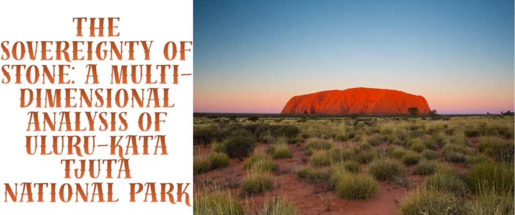
The Australian interior is defined by a landscape of profound antiquity, where the geological record and human cultural memory converge in a manner found in few other places on Earth. Uluru-Kata Tjuta National Park, a 1,326-square-kilometre sanctuary in the southwestern corner of the Northern Territory, serves as the primary custodian of this intersection.1 Recognised globally through its dual UNESCO World Heritage listing—achieved for natural values in 1987 and as a cultural landscape in 1994—the park represents more than a collection of iconic landforms; it is a living entity managed through a sophisticated partnership between the Anangu Traditional Owners and the Australian Government.3
The geographical heart of the “Red Centre,” situated approximately 440 kilometres from Alice Springs, is dominated by the massive sandstone monolith of Uluru and the 36 conglomerate domes of Kata Tjuta.2 These formations are not merely static monuments but are the surface expressions of geological processes spanning nearly a billion years and are central to the Tjukurpa, the ancestral law and religious philosophy that guides every aspect of Anangu life.7 As the park moves through 2026, it enters a period of significant administrative and experiential evolution, marked by landmark lease renewals that double the revenue shared with Traditional Owners and the introduction of premium multi-day trekking experiences that allow for deeper wilderness immersion.9
Geological Genesis and the Amadeus Basin
The physical existence of Uluru and Kata Tjuta is rooted in the deep-time history of the Amadeus Basin, a massive depression in the Earth’s crust that began forming approximately 900 million years ago.7 For several hundred million years, this basin served as a catchment for layer upon layer of sediment, at times existing as a shallow inland sea.7 The structural foundations of the monoliths were laid during the Petermann Ranges Orogeny, a mountain-building event occurring roughly 550 million years ago.7 During this era, the lack of terrestrial vegetation meant that the newly formed mountain ranges were subjected to rapid, uninhibited erosion. This process resulted in the formation of massive alluvial fans—sedimentary deposits that eventually compressed into the rocks observed today.7
Orogeny and Tectonic Transformation
The divergence in the physical appearance of Uluru and Kata Tjuta is a direct consequence of their specific sedimentary origins within these alluvial fans. Uluru is composed of arkose, a coarse-grained sandstone rich in feldspar, which was derived from the erosion of granite mountains.7 Kata Tjuta, conversely, is formed from conglomerate rock—a heterogeneous mixture of granite and basalt boulders, cobbles, and pebbles cemented by a sandy matrix.7 The subsequent Alice Springs Orogeny, occurring between 400 and 300 million years ago, provided the final tectonic impetus, folding and fracturing the hardened sediments.7 This event was responsible for the unique orientation of the strata: while the conglomerate layers of Kata Tjuta were tilted only 15 to 20 degrees, the arkose layers of Uluru were turned nearly 90 degrees to a near-vertical position.7
| Geological Event | Approximate Timing | Impact on Landscape |
| Amadeus Basin Formation | 900 MYA | Creation of the sedimentary catchment area 7 |
| Petermann Ranges Orogeny | 550 MYA | Mountain building and formation of alluvial fans 7 |
| Shallow Sea Inundation | 500 MYA | Compression and cementing of sand and gravel 13 |
| Alice Springs Orogeny | 400–300 MYA | Tectonic folding, fracturing, and 90-degree tilting 7 |
| Emergence of Modern Forms | 65 MYA | Erosion of softer surrounding earth leaves monoliths 12 |
The ongoing weathering of these forms is a nuanced process. While wind-blown sand affects the rock at its base, the majority of the sculpting is attributed to chemical decay and mechanical erosion caused by moisture.7 On the southern face of Uluru, rain runoff has carved steep valleys, potholes, and plunge pools into the vertical strata, while the distinctive “flaky” surface of the monolith is the result of mineral oxidation—essentially a layer of rust that masks the grey colour of the fresh arkose beneath.7
Tjukurpa: The Foundation of Anangu Existence
To the Anangu people—the Pitjantjatjara and Yankunytjatjara—the geological explanations of orogeny and erosion are complementary to, rather than exclusionary of, the spiritual reality of Tjukurpa.8 Tjukurpa is a complex religious philosophy that links the Anangu to their environment and their ancestors, encompassing the creation period when ancestral beings shaped the world.8 These beings, which often manifested as combinations of humans, plants, and animals, travelled across the featureless landscape, performing deeds that left behind tjukuritja—physical evidence in the form of rocks, caves, and waterholes.8
The Mechanism of Songlines and Oral Tradition
The journeys of these ancestors are recorded in iwara, or songlines, which serve as sophisticated navigational and educational tools.8 These narratives are memorised and passed down through generations via inma (songs and ceremonies), storytelling, and art.8 Because Tjukurpa provides the rules for appropriate behaviour, land management, and social relationships, it functions as both a moral compass and a justice system.8 Knowledge of Tjukurpa is not universally accessible; it is earned and inherited, with specific sections of stories being restricted to initiated men or women, or to those with a direct ancestral connection to a particular site.8
Key Creation Narratives at Uluru
Several primary narrative cycles are physically represented in the features of Uluru. The Mala (rufous hare-wallaby) Tjukurpa describes the arrival of the Mala people from the north and their subsequent ceremonies at the rock.8 The Kuniya (woma python) and Liru (poisonous snake) Tjukurpa recounts a fierce battle at the Mutitjulu Waterhole, where the scars and indentations in the rock face are understood as the physical manifestations of the combatants’ actions.8 Another cycle involving Lungkata (the blue-tongued lizard) teaches lessons on the consequences of greed and the importance of sharing resources.8 These stories are not viewed as myths but as an active, unchanging Law that governs the present.8
The Historical Trajectory of Sovereignty and Handback
The modern history of the park is defined by the Anangu’s struggle to reclaim custodianship over their traditional lands. Following decades of dispossession by pastoral and tourism interests, the 1970s marked a turning point in Aboriginal land rights.17 In 1979, a successful land claim was lodged for areas surrounding the park, but the park itself remained under federal control until the political landscape shifted in the early 1980s.19
The 1985 Handback and Joint Management
The “Handback” on October 26, 1985, remains one of the most significant moments in Australian history. At a ceremony held in the Mutitjulu community, Governor-General Sir Ninian Stephen returned the title deeds for the park to the Anangu Traditional Owners.17 Simultaneously, the Anangu leased the land back to the Director of National Parks for 99 years, establishing a joint management framework.18 This arrangement ensures that the park is managed according to both Western scientific conservation principles and the traditional ecological knowledge of Tjukurpa.5
A major milestone in this ongoing relationship occurred on October 26, 2019, when the climb up Uluru was permanently closed.17 For decades, the Anangu had requested that visitors refrain from climbing the rock, as the path followed a sacred route taken by the Mala ancestors, and the practice led to environmental degradation and safety concerns.17 The closure was a symbolic and practical affirmation of Anangu sovereignty and cultural authority over the site.21
Governance and the 2026 Lease Overhaul
As of April 2, 2026, the leasing arrangements between the Anangu and the Australian Government have undergone a historic variation, the first major update since the early 1990s.9 This overhaul was designed to strengthen joint management and ensure that the economic benefits of tourism are more equitably distributed to the Traditional Owners.9
Revenue Sharing and Economic Empowerment
Under the revised 2026 lease, the revenue-sharing model has been significantly altered. The Anangu now receive 50 per cent of the total park revenue, a substantial increase from the previous 25 per cent.9 This funding is utilised by the Central Land Council to support community projects, including education, healthcare, and infrastructure in the Mutitjulu community and surrounding homelands.9
| Lease Provision | Pre-2026 Arrangement | 2026 Updated Arrangement |
| Revenue Share to Anangu | 25% of park entry fees | 50% of total park revenue 9 |
| Joint Management Principles | General cooperation | Codified respect for Tjukurpa and social wellbeing 9 |
| Cultural Awareness | Recommended training | Mandatory training for all park staff 23 |
| Sacred Site Protection | Standard protections | Enhanced legislative and operational protections 23 |
The Board of Management serves as the executive decision-making body for the park. It comprises 12 members, with a statutory requirement for a majority of Anangu members nominated by the Traditional Owners.5 This structure ensures that management plans for fire, feral animals, and visitor access are always viewed through the lens of Tjukurpa.5
Botanical Resilience and Fire Management
The arid ecosystem of the park is characterised by extreme conditions, with annual rainfall averaging less than 300 millimetres.27 Despite this, the park supports 418 native plant species, many of which have developed specialised adaptations to survive high temperatures and drought.16 The vegetation ranges from dense Mulga woodlands to expansive spinifex grasslands, with the distribution being heavily influenced by soil type and the availability of water runoff from the monoliths.27
Flora: Adaptive Strategies and Cultural Utility
Plants within the park are categorised by the Anangu into groups such as mai (plant foods) and tjuratja (sweet foods), with many species also serving as sources of medicine and material for tools.8
- Wanari (Mulga – Acacia aneura): The most common group of trees in the park, Mulga produces a dense, resinous hardwood used for making spear throwers (miru) and digging sticks (wana). The seeds are also harvested and ground into flour.8
- Kurkara (Desert Oak – Allocasuarina decaisneana): These slow-growing trees can live for over 1,000 years. Juvenile trees have a narrow, twig-like profile to minimise water loss, while mature trees develop thick, corky bark that protects them from fire.27
- Muur-muurpa (Desert Bloodwood – Eucalyptus terminalis): Known for its rough, square-patterned bark, this tree produces a red sap that Anangu use as a disinfectant for coughs and colds.27
- Altarpa (Blue Mallee – Eucalyptus gamophylla): This species can resprout from a large underground root after a fire, forming multiple new trunks.27
Fire-Stick Farming and Mosaic Burning
The health of the park’s flora is inextricably linked to the practice of “fire-stick farming” or cultural burning.30 This traditional land management technique involves lighting small, controlled fires to clear old vegetation, encourage the growth of new food plants, and prevent large-scale, high-intensity wildfires.31 When Anangu were discouraged from these practices in the mid-20th century, the accumulation of fuel led to catastrophic wildfires in 1950 and 1976 that destroyed over 75 per cent of the park’s vegetation.32 Today, rangers and Traditional Owners work together to implement winter patch burning, creating a mosaic of burnt and unburnt areas that act as natural firebreaks and support biodiversity.32
Zoological Diversity and Conservation Challenges
The park serves as a critical habitat for 21 native mammal species, over 200 bird species, and 73 reptile species.1 Many of these animals are nocturnal or have developed physiological mechanisms to cope with the desert heat, such as the perentie lizard and the sand goanna.1
The Mala Reintroduction Project
A primary focus of the park’s conservation efforts is the Mala (rufous hare-wallaby), a species that became extinct in the wild on the Australian mainland due to predation by feral cats and foxes.32 Since 2005, a predator-proof enclosure has been maintained within the park to house a breeding population of Mala.32 This program is not only an ecological priority but a cultural one, as the Mala are central to one of the most important Tjukurpa stories of Uluru.8
Invasive Species and Management Issues
The ecological integrity of the park is currently threatened by several invasive species. Buffel grass (Cenchrus ciliaris), introduced for erosion control, has spread widely, choking out native grasses and increasing the intensity of fires.32 Management strategies include resource-intensive hand-removal and the experimental use of herbicides.32 Additionally, feral animals such as camels, red foxes, and cats are controlled to minimise their impact on native vegetation and vulnerable fauna like the Great Desert Skink and the Southern Marsupial Mole.32
The Modern Visitor Experience: Ethics and Logistics
Tourism in 2026 is characterised by a shift toward high-value, low-impact experiences that prioritise cultural education over simple sightseeing.10 Visitors are encouraged to engage with the park through a lens of respect, following strict guidelines regarding photography and access to sacred sites.36
The 2026 Signature Walk
April 2026 saw the launch of the Uluru-Kata Tjuta Signature Walk, a premium 5-day, 54-kilometre guided trek.10 Developed by the Tasmanian Walking Company in partnership with the Anangu, it is the first long-distance walk to offer overnight stays inside the national park boundaries.10
| Walk Feature | Details |
| Duration | 5 days / 4 nights 39 |
| Distance | 54 kilometres 38 |
| Group Size | Maximum 16 guests 10 |
| Accommodation | Architecturally designed eco-camps and private lodge 39 |
| Seasonal Operation | April to September (Cool Season) 10 |
| Cost | From $5,395 per person 10 |
| Community Contribution | $500 per guest to Anangu and conservation funds 39 |
This experience represents a significant diversification of the park’s tourism product, targeting the “high-yield adventure traveller” and ensuring that a portion of the premium price goes directly toward Anangu business development and environmental upkeep.10
Cultural Immersion and Digital Experiences
Beyond trekking, the park offers a variety of experiences designed to convey the complexity of Tjukurpa to a global audience.
- Wintjiri Wiru: A massive drone show involving over 1,000 luminous drones that depict the Mala story through light and sound.40
- Cultural Centre: A central hub for visitors to learn about Anangu law and art. It is the only place in the park where traditional wooden tools and dot paintings can be purchased directly from local artists.8
- Ranger-Guided Mala Walk: A free daily activity that explores the base of Uluru, detailing the arrival of the Mala ancestors and the conservation work of the rangers.16
Climate, Seasonality, and Safety
The weather in the Red Centre is characterised by extreme temperature fluctuations, making planning essential for visitor safety.28
| Month | Avg Max Temp (°C) | Avg Min Temp (°C) | Avg Rainfall (mm) |
| January | 38.4 | 22.8 | 28.8 |
| February | 37.0 | 22.1 | 38.4 |
| March | 34.5 | 19.3 | 32.6 |
| April | 29.9 | 14.5 | 15.7 |
| May | 24.3 | 9.3 | 14.3 |
| June | 20.4 | 5.6 | 18.2 |
| July | 20.6 | 4.4 | 17.6 |
| August | 23.7 | 5.9 | 5.0 |
| September | 28.7 | 10.7 | 9.0 |
| October | 32.3 | 14.9 | 21.1 |
| November | 35.1 | 18.4 | 33.1 |
| December | 36.5 | 20.8 | 45.5 |
The park’s management issues heat safety warnings from October to March, advising visitors to complete all walks before 11:00 am when temperatures frequently exceed 35°C.28 Conversely, winter months (June to August) can see nighttime temperatures drop below freezing, requiring specialised gear for campers and early-morning walkers.44 January is typically the wettest month, often triggering the spectacular sight of waterfalls cascading down the steep faces of Uluru.28
Conclusion
Uluru-Kata Tjuta National Park is a landscape defined by its dualities: it is at once a site of immense geological antiquity and a contemporary stage for Indigenous self-determination. The 2026 lease overhaul and the introduction of initiatives like the Signature Walk mark a new chapter in the joint management of the park, one that prioritises economic justice for the Anangu and deeper cultural immersion for the visitor. As the monoliths of arkose and conglomerate weather the passage of time, they remain the physical vessels of the Tjukurpa—a living law that continues to resonate across the red sands of the Australian interior.
Disclaimer
This article provides a comprehensive overview of the park’s geological, cultural, and administrative status as of early 2026. Visitors are strongly encouraged to consult the official Uluṟu-Kata Tjuṯa National Park and Parks Australia websites for current entry fees, seasonal closures, and cultural protocols before planning their journey. The information herein is intended for research and educational purposes and does not replace the guidance of the Traditional Owners or park management authorities.
References
- Uluru-Kata Tjuta National Park | (Official GANP Page), accessed on May 5, 2026, https://national-parks.org/australia/uluru-kata-tjuta/
- Uluṟu-Kata Tjuṯa National Park – Wikipedia, accessed on May 5, 2026, https://en.wikipedia.org/wiki/Ulu%E1%B9%9Fu-Kata_Tju%E1%B9%AFa_National_Park
- World heritage | Uluṟu-Kata Tjuṯa National Park | Parks Australia, accessed on May 5, 2026, https://uluru.gov.au/discover/highlights/world-heritage/
- World heritage – Uluṟu-Kata Tjuṯa National Park, accessed on May 5, 2026, https://uluru.gov.au/static/d79ad1137575ecc674d8d2dae80cd815/uktnp-document-fs-worldheritage.pdf
- Joint management | Uluṟu-Kata Tjuṯa National Park | Parks Australia, accessed on May 5, 2026, https://uluru.gov.au/about/joint-management/
- Uluru-Kata Tjuta National Park – DCCEEW, accessed on May 5, 2026, https://www.dcceew.gov.au/parks-heritage/heritage/places/world/uluru
- Geology – Uluṟu-Kata Tjuṯa National Park, accessed on May 5, 2026, https://uluru.gov.au/static/cb2d9a32e0ee507fca49cc3642552d8d/uktnp-a4factsheet-geology_23-sept.pdf
- Tjukurpa | Uluṟu-Kata Tjuṯa National Park | Parks Australia, accessed on May 5, 2026, https://uluru.gov.au/discover/culture/tjukurpa/
- Uluru-Kata Tjuta lease update strengthens joint management and doubles revenue for Anangu | Ministers’ media centre, accessed on May 5, 2026, https://ministers.pmc.gov.au/mccarthy/uluru-kata-tjuta-lease-update-strengthens-joint-management-and-doubles-revenue-anangu
- Uluru-Kata Tjuta Signature Walk launches as first new national park trek in a decade, accessed on May 5, 2026, https://www.travelmonitor.com.au/uluru-kata-tjuta-signature-walk-launches-as-first-new-national-park-trek-in-a-decade/
- New multi-day Uluṟu walk gives back to community – Parks Australia, accessed on May 5, 2026, https://parksaustralia.gov.au/news/new-multi-day-uluru-walk-gives-back-community
- An Immense Monolith and Oddly Shaped Huge Rock Formations: Uluru and Kata Tjuta, Australia | 2007 – JAXA Earth Observation Research Center, accessed on May 5, 2026, https://www.eorc.jaxa.jp/en/earthview/2007/tp070307.html
- Earth from Space: Uluru/Ayers Rock, Australia – ESA, accessed on May 5, 2026, https://www.esa.int/Applications/Observing_the_Earth/Proba-1/Earth_from_Space_Uluru_Ayers_Rock_Australia
- Geomorphology of Uluru, Australia – Answers Research Journal, accessed on May 5, 2026, https://assets.answersresearchjournal.org/doc/v3/geomorphology-uluru.pdf
- Significant Rock Features | Geoscience Australia, accessed on May 5, 2026, https://www.ga.gov.au/scientific-topics/national-location-information/landforms/significant-rock-features
- Uluru-Kata Tjuta National Park | Ayers Rock Resort, accessed on May 5, 2026, https://www.ayersrockresort.com.au/our-story/exploring-uluru-and-kata-tjuta-national-park
- Handback of Uluru to the Anangu – National Museum of Australia, accessed on May 5, 2026, https://www.nma.gov.au/defining-moments/resources/uluru-handback-anangu
- Acknowledging the handback of Uluru–Kata Tjuta – Indigenous.gov.au, accessed on May 5, 2026, https://www.indigenous.gov.au/stories/acknowledging-handback-uluru-kata-tjuta
- Handback of Uluru to the Anangu | Australia’s Defining Moments Digital Classroom, accessed on May 5, 2026, https://digital-classroom.nma.gov.au/defining-moments/handback-uluru-anangu
- History of Uluṟu-Kata Tjuṯa National Park, accessed on May 5, 2026, https://uluru.gov.au/discover/history/
- Marking 40 years since the Handback of Uluru – Prime Minister of Australia, accessed on May 5, 2026, https://www.pm.gov.au/media/marking-40-years-handback-uluru
- Uluru Handback: 40 Years in Anangu hands – Indigenous.gov.au, accessed on May 5, 2026, https://www.indigenous.gov.au/stories/uluru-handback-40-years-anangu-hands
- Joint media release: Uluru-Kata Tjuta lease update strengthens joint management and doubles revenue for Anangu | Ministers, accessed on May 5, 2026, https://minister.dcceew.gov.au/watt/media-releases/joint-media-release-uluru-kata-tjuta-lease-update-strengthens-joint-management-and-doubles-revenue-anangu
- Joint management strengthened, revenue doubled for Aṉangu in Uluṟu lease overhaul, accessed on May 5, 2026, https://nit.com.au/02-04-2026/23524/joint-management-strenghtened-revenue-doubled-for-aangu-in-uluu-lease-overhaul
- Uluṟu-Kata Tjuṯa Board of Management – Australian Government Directory, accessed on May 5, 2026, https://www.directory.gov.au/portfolios/climate-change-energy-environment-and-water/director-national-parks/uluru-kata-tjuta-board-management
- Member – Australian Government Directory, accessed on May 5, 2026, https://www.directory.gov.au/portfolios/climate-change-energy-environment-and-water/director-national-parks/uluru-kata-tjuta-board-management/member-0
- Fact Sheet, accessed on May 5, 2026, https://www.agriculture.gov.au/sites/default/files/documents/uktnp-a4factsheet-flora-small.pdf
- When to come | Uluṟu-Kata Tjuṯa National Park | Parks Australia, accessed on May 5, 2026, https://uluru.gov.au/plan/when-to-come/
- ULURU – KATA TJUTA NATIONAL PARK – World Heritage Datasheet, accessed on May 5, 2026, http://world-heritage-datasheets.unep-wcmc.org/datasheet/output/site/uluru-kata-tjuta-national-park/
- Land, resource & fire managers: Australia’s First Peoples – Australian Academy of the Humanities, accessed on May 5, 2026, https://humanities.org.au/power-of-the-humanities/aboriginal-land-management-and-extreme-weather/
- Fire-stick farming – Wikipedia, accessed on May 5, 2026, https://en.wikipedia.org/wiki/Fire-stick_farming
- Conservation | Uluṟu-Kata Tjuṯa National Park | Parks Australia, accessed on May 5, 2026, https://uluru.gov.au/discover/nature/conservation/
- Articles about Traditional Knowledge, Cultural Burns and Land Management – Landcare Australia, accessed on May 5, 2026, https://landcareaustralia.org.au/resources/first-nations-resources-and-guidelines/cultural-burns-and-land-management/
- Uluru and surrounds, accessed on May 5, 2026, https://dli.nt.gov.au/__data/assets/pdf_file/0019/242074/61_uluru.pdf
- Uluru-Kata Tjuta Signature Walk Redefines Luxury Desert Trekking with First Overnight Experience Inside National Park – Travel Span, accessed on May 5, 2026, https://travelspan.in/uluru-kata-tjuta-signature-walk-redefines-luxury-desert-trekking-with-first-overnight-experience-inside-national-park/
- Respecting Culture | Uluṟu-Kata Tjuṯa National Park | Parks Australia, accessed on May 5, 2026, https://uluru.gov.au/discover/culture/respecting-culture/
- Information about film and photography at Uluṟu-Kata Tjuṯa National Park – Parks Australia, accessed on May 5, 2026, https://parksaustralia.gov.au/news/information-about-film-and-photography-uluru-kata-tjuta-national-park/
- Uluru-Kata Tjuta Signature Walk | tour by Australian Walking Company – Northern Territory, accessed on May 5, 2026, https://northernterritory.com/us/en/tours/australian-walking-company/uluru-kata-tjuta-signature-walk
- Uluṟu-Kata Tjuṯa Signature Walk – Great Walks of Australia, accessed on May 5, 2026, https://greatwalksofaustralia.com.au/our-walks/uluru-kata-tjuta-signature-walk/
- Filming and Photography Guidelines – Ayers Rock Resort, accessed on May 5, 2026, https://www.ayersrockresort.com.au/events/filming-and-photography-guidelines
- Guided tours around Uluru | Uluru & Surrounds | NT, Australia, accessed on May 5, 2026, https://northernterritory.com/uluru-and-surrounds/tours
- Tours & experiences | Uluṟu-Kata Tjuṯa National Park | Parks Australia, accessed on May 5, 2026, https://uluru.gov.au/things-do/tours-experiences/
- Weather & seasons – Northern Territory, accessed on May 5, 2026, https://northernterritory.com/plan/weather-and-seasons
- Weather in Uluru and Alice Springs, NT – Tourism Australia, accessed on May 5, 2026, https://www.australia.com/en-us/facts-and-planning/weather-in-australia/alice-springs-weather.html
- Weather & Climate | Ayers Rock Resort, accessed on May 5, 2026, https://www.ayersrockresort.com.au/our-story/weather